Cuddalore geodata
Cuddalore (Tamil Nadu) is a populated place; located in India in Asia/Kolkata (GMT+5.5) time zone. With population of 158,569 people, there are 275 cities with bigger population in this country. Compared to other cities in India, 90.4% of cities are located further ↑North; 66.2% of cities are located further ←West and 93.5% of cities have higher elevation than Cuddalore. Note1


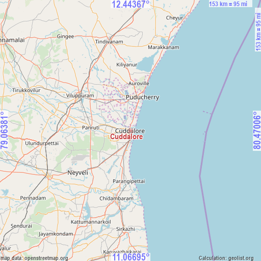
Cuddalore GPS coordinates[2]
11° 45' 22.212" North, 79° 46' 0.948" East
| Map corner | latitude | longitude |
|---|---|---|
| Upper-left | 12.44367°, | 79.06381° |
| Center: | 11.75617°, | 79.76693° |
| Lower-right: | 11.06695°, | 80.47006° |
| Map W x H: | 153.1×153.1 km | = 95.1×95.1mi |
| max Lat: | 34.9274° ⇑90.4% North |
| Cuddalore: | 11.75617° |
| min Lat: | ⇓9.6% South 8.09008° |
| min Long | Cuddalore | max Long |
| 68.82655° | 79.76693° | 96.81° |
| W 66.2%⇐ | ⇒33.8% E |
Elevation
Elevation of Cuddalore is 13 m = 43 ft, and this is 282.6 m = 927 ft below average elevation for this country.
| Max E: |
3681 m = 12077 ft | 93.5% |
| Avg. | 295.6 m = 970 ft | |
| Cuddalore | 13 m = 43 ft | |
Min E: |
1 m = 3 ft | 6.5% |
See also: Cuddalore elevation on elevation.city.
Geographical zone
Cuddalore is located in North Torrid zone (between Equator and Tropic of Cancer). Distance of this Northern Tropic circle is 1298.8 km =807 mi to North.| Distance of | km | miles | from Cuddalore |
|---|---|---|---|
| North Pole | 8699.9 | 5405.9 | to North |
| Arctic Circle | 6094 | 3786.6 | to North |
| Tropic Cancer | 1298.8 | 807 | to North |
| Equator | 1307.2 | 812.3 | to South |


Nearby cities:
15 places around Cuddalore: (largest is in red/bold)
• Annāmalainagar
39.8 km =24.7 mi,  185°
185°
• Auroville
28.1 km =17.5 mi,  9°
9°
• Chidambaram
40.5 km =25.2 mi, 191°
• Kurinjippādi
29.9 km =18.6 mi,  219°
219°
• Kīl Bhuvanagiri
37.3 km =23.2 mi,  200°
200°
• Marakkanam
52.1 km =32.4 mi,  21°
21°
• Nellikkuppam
10.8 km =6.7 mi,  281°
281°
• Panruti
23.4 km =14.5 mi, 275°
• Puducherry
20.9 km =13 mi, 19°
• Tindivanam
54.5 km =33.9 mi,  347°
347°
• Valavanur
27.2 km =16.9 mi,  312°
312°
• Vikravāndi
39.4 km =24.5 mi,  322°
322°
• Villupuram
36.2 km =22.5 mi,  304°
304°
• Vriddhāchalam
55 km =34.2 mi,  241°
241°
• Ālappākkam
18.2 km =11.3 mi, 196°
Sources, notices
• [Note1] Compared only with cities in India existing in our database
• [Src1] Map data: © OpenStreetMap contributors (CC-BY-SA)
• [Src2] Other city data from geonames.org with taken over terms of usage.
• [Src3] Geographical zone / Annual Mean Temperature by Robert A. Rohde @ Wikipedia
