Puducherry geodata
Puducherry is a seat of a first-order administrative division; located in India in Asia/Kolkata (GMT+5.5) time zone. With population of 227,411 people, there are 186 cities with bigger population in this country. Compared to other cities in India, 89.9% of cities are located further ↑North; 66.6% of cities are located further ←West and 95.4% of cities have higher elevation than Puducherry. Note1


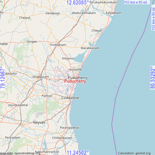
Puducherry GPS coordinates[2]
11° 56' 1.716" North, 79° 49' 47.244" East
| Map corner | latitude | longitude |
|---|---|---|
| Upper-left | 12.62085°, | 79.12667° |
| Center: | 11.93381°, | 79.82979° |
| Lower-right: | 11.24502°, | 80.53292° |
| Map W x H: | 153×153 km | = 95.1×95.1mi |
| max Lat: | 34.9274° ⇑89.9% North |
| Puducherry: | 11.93381° |
| min Lat: | ⇓10.1% South 8.09008° |
| min Long | Puducherry | max Long |
| 68.82655° | 79.82979° | 96.81° |
| W 66.6%⇐ | ⇒33.4% E |
Elevation
Elevation of Puducherry is 11 m = 36 ft, and this is 284.6 m = 934 ft below average elevation for this country.
| Max E: |
3681 m = 12077 ft | 95.4% |
| Avg. | 295.6 m = 970 ft | |
| Puducherry | 11 m = 36 ft | |
Min E: |
1 m = 3 ft | 4.6% |
See also: Puducherry elevation on elevation.city.
Geographical zone
Puducherry is located in North Torrid zone (between Equator and Tropic of Cancer). Distance of this Northern Tropic circle is 1279 km =794.7 mi to North.| Distance of | km | miles | from Puducherry |
|---|---|---|---|
| North Pole | 8680.1 | 5393.6 | to North |
| Arctic Circle | 6074.3 | 3774.4 | to North |
| Tropic Cancer | 1279 | 794.7 | to North |
| Equator | 1326.9 | 824.5 | to South |


Nearby cities:
15 places around Puducherry: (largest is in red/bold)
• Auroville
8.3 km =5.2 mi,  344°
344°
• Cheyyur
49.9 km =31 mi,  22°
22°
• Cuddalore
20.9 km =13 mi,  199°
199°
• Gingee
57.2 km =35.5 mi,  308°
308°
• Kurinjippādi
50 km =31.1 mi,  211°
211°
• Kīl Bhuvanagiri
58.2 km =36.2 mi, 199°
• Marakkanam
31.2 km =19.4 mi, 23°
• Nangilickondan
52.6 km =32.7 mi, 312°
• Nellikkuppam
24.7 km =15.3 mi,  224°
224°
• Panruti
34.9 km =21.7 mi,  239°
239°
• Tindivanam
38.4 km =23.9 mi,  330°
330°
• Valavanur
27 km =16.8 mi,  266°
266°
• Vikravāndi
32.9 km =20.4 mi,  290°
290°
• Villupuram
36.7 km =22.8 mi, 271°
• Ālappākkam
39.1 km =24.3 mi, 197°
In other languages:
- In France: Pondichéry
- In German: Pondicherry
- In Russian: Пондишери
- In Chinese: 本地治里
Sources, notices
• [Note1] Compared only with cities in India existing in our database
• [Src1] Map data: © OpenStreetMap contributors (CC-BY-SA)
• [Src2] Other city data from geonames.org with taken over terms of usage.
• [Src3] Geographical zone / Annual Mean Temperature by Robert A. Rohde @ Wikipedia
