Villupuram geodata
Villupuram (Tamil Nadu) is a populated place; located in India in Asia/Kolkata (GMT+5.5) time zone. With population of 97,380 people, there are 453 cities with bigger population in this country. Compared to other cities in India, 89.9% of cities are located further ↑North; 63.7% of cities are located further ←West and 79.4% of cities have higher elevation than Villupuram. Note1


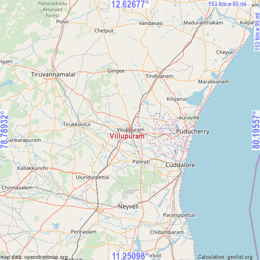
Villupuram GPS coordinates[2]
11° 56' 23.1" North, 79° 29' 32.784" East
| Map corner | latitude | longitude |
|---|---|---|
| Upper-left | 12.62677°, | 78.78932° |
| Center: | 11.93975°, | 79.49244° |
| Lower-right: | 11.25098°, | 80.19557° |
| Map W x H: | 153×153 km | = 95.1×95.1mi |
| max Lat: | 34.9274° ⇑89.9% North |
| Villupuram: | 11.93975° |
| min Lat: | ⇓10.1% South 8.09008° |
| min Long | Villupuram | max Long |
| 68.82655° | 79.49244° | 96.81° |
| W 63.7%⇐ | ⇒36.3% E |
Elevation
Elevation of Villupuram is 50 m = 164 ft, and this is 245.6 m = 806 ft below average elevation for this country.
| Max E: |
3681 m = 12077 ft | 79.4% |
| Avg. | 295.6 m = 970 ft | |
| Villupuram | 50 m = 164 ft | |
Min E: |
1 m = 3 ft | 20.6% |
See also: Villupuram elevation on elevation.city.
Geographical zone
Villupuram is located in North Torrid zone (between Equator and Tropic of Cancer). Distance of this Northern Tropic circle is 1278.3 km =794.3 mi to North.| Distance of | km | miles | from Villupuram |
|---|---|---|---|
| North Pole | 8679.5 | 5393.2 | to North |
| Arctic Circle | 6073.6 | 3774 | to North |
| Tropic Cancer | 1278.3 | 794.3 | to North |
| Equator | 1327.6 | 824.9 | to South |


Nearby cities:
15 places around Villupuram: (largest is in red/bold)
• Auroville
35.2 km =21.9 mi,  78°
78°
• Cuddalore
36.2 km =22.5 mi,  124°
124°
• Gingee
35.8 km =22.2 mi,  346°
346°
• Kurinjippādi
44.6 km =27.7 mi,  166°
166°
• Manalūrpettai
44.2 km =27.5 mi,  279°
279°
• Nangilickondan
35.1 km =21.8 mi,  356°
356°
• Nellikkuppam
26.6 km =16.5 mi,  133°
133°
• Panruti
19.3 km =12 mi,  160°
160°
• Pennāthur
44.8 km =27.8 mi,  319°
319°
• Puducherry
36.7 km =22.8 mi,  91°
91°
• Tindivanam
37.2 km =23.1 mi,  28°
28°
• Tirukkoyilur
31.7 km =19.7 mi, 275°
• Valavanur
10 km =6.2 mi,  102°
102°
• Vettavalam
32.7 km =20.3 mi,  304°
304°
• Vikravāndi
12.3 km =7.6 mi, 28°
Sources, notices
• [Note1] Compared only with cities in India existing in our database
• [Src1] Map data: © OpenStreetMap contributors (CC-BY-SA)
• [Src2] Other city data from geonames.org with taken over terms of usage.
• [Src3] Geographical zone / Annual Mean Temperature by Robert A. Rohde @ Wikipedia
