Valavanur geodata
Valavanur (Tamil Nadu) is a populated place; located in India in Asia/Kolkata (GMT+5.5) time zone. With population of 14,463 people, there are 2513 cities with bigger population in this country. Compared to other cities in India, 90% of cities are located further ↑North; 64.6% of cities are located further ←West and 83.9% of cities have higher elevation than Valavanur. Note1


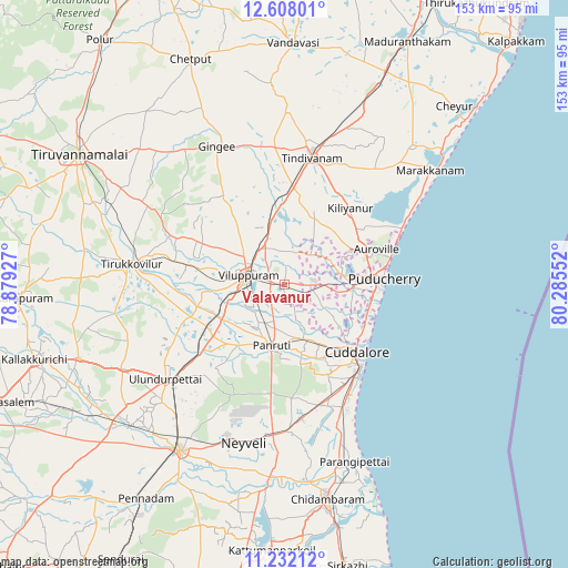
Valavanur GPS coordinates[2]
11° 55' 15.384" North, 79° 34' 56.604" East
| Map corner | latitude | longitude |
|---|---|---|
| Upper-left | 12.60801°, | 78.87927° |
| Center: | 11.92094°, | 79.58239° |
| Lower-right: | 11.23212°, | 80.28552° |
| Map W x H: | 153×153 km | = 95.1×95.1mi |
| max Lat: | 34.9274° ⇑90% North |
| Valavanur: | 11.92094° |
| min Lat: | ⇓10% South 8.09008° |
| min Long | Valavanur | max Long |
| 68.82655° | 79.58239° | 96.81° |
| W 64.6%⇐ | ⇒35.4% E |
Elevation
Elevation of Valavanur is 34 m = 112 ft, and this is 261.6 m = 858 ft below average elevation for this country.
| Max E: |
3681 m = 12077 ft | 83.9% |
| Avg. | 295.6 m = 970 ft | |
| Valavanur | 34 m = 112 ft | |
Min E: |
1 m = 3 ft | 16.1% |
See also: India elevation on elevation.city.
Geographical zone
Valavanur is located in North Torrid zone (between Equator and Tropic of Cancer). Distance of this Northern Tropic circle is 1280.4 km =795.6 mi to North.| Distance of | km | miles | from Valavanur |
|---|---|---|---|
| North Pole | 8681.6 | 5394.5 | to North |
| Arctic Circle | 6075.7 | 3775.3 | to North |
| Tropic Cancer | 1280.4 | 795.6 | to North |
| Equator | 1325.5 | 823.6 | to South |


Nearby cities:
15 places around Valavanur: (largest is in red/bold)
• Auroville
26.4 km =16.4 mi,  69°
69°
• Cuddalore
27.2 km =16.9 mi,  132°
132°
• Gingee
41 km =25.5 mi,  334°
334°
• Kurinjippādi
41.2 km =25.6 mi,  178°
178°
• Marakkanam
49.4 km =30.7 mi,  52°
52°
• Nangilickondan
39 km =24.2 mi,  342°
342°
• Nellikkuppam
18.8 km =11.7 mi,  149°
149°
• Panruti
16.4 km =10.2 mi,  191°
191°
• Puducherry
27 km =16.8 mi,  86°
86°
• Tindivanam
35.7 km =22.2 mi,  12°
12°
• Tirukkoyilur
41.6 km =25.8 mi,  276°
276°
• Vettavalam
42.1 km =26.2 mi,  299°
299°
• Vikravāndi
13.5 km =8.4 mi, 342°
• Villupuram
10 km =6.2 mi, 282°
• Ālappākkam
38.8 km =24.1 mi,  157°
157°
Sources, notices
• [Note1] Compared only with cities in India existing in our database
• [Src1] Map data: © OpenStreetMap contributors (CC-BY-SA)
• [Src2] Other city data from geonames.org with taken over terms of usage.
• [Src3] Geographical zone / Annual Mean Temperature by Robert A. Rohde @ Wikipedia
