Vikravāndi geodata
Vikravāndi (Tamil Nadu) is a populated place; located in India in Asia/Kolkata (GMT+5.5) time zone. With population of 10,449 people, there are 2894 cities with bigger population in this country. Compared to other cities in India, 89.7% of cities are located further ↑North; 64.2% of cities are located further ←West and 81.4% of cities have higher elevation than Vikravāndi. Note1


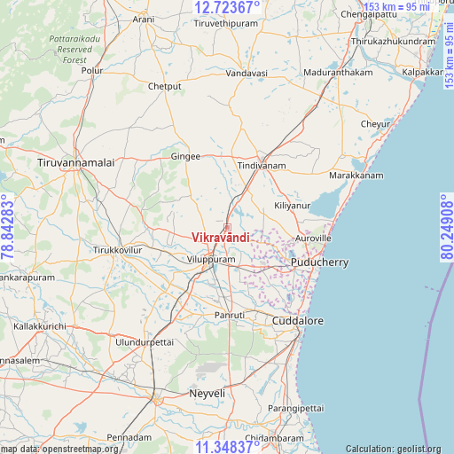
Vikravāndi GPS coordinates[2]
12° 2' 12.84" North, 79° 32' 45.42" East
| Map corner | latitude | longitude |
|---|---|---|
| Upper-left | 12.72367°, | 78.84283° |
| Center: | 12.0369°, | 79.54595° |
| Lower-right: | 11.34837°, | 80.24908° |
| Map W x H: | 152.9×152.9 km | = 95×95mi |
| max Lat: | 34.9274° ⇑89.7% North |
| Vikravāndi: | 12.0369° |
| min Lat: | ⇓10.3% South 8.09008° |
| min Long | Vikravāndi | max Long |
| 68.82655° | 79.54595° | 96.81° |
| W 64.2%⇐ | ⇒35.8% E |
Elevation
Elevation of Vikravāndi is 43 m = 141 ft, and this is 252.6 m = 829 ft below average elevation for this country.
| Max E: |
3681 m = 12077 ft | 81.4% |
| Avg. | 295.6 m = 970 ft | |
| Vikravāndi | 43 m = 141 ft | |
Min E: |
1 m = 3 ft | 18.6% |
See also: India elevation on elevation.city.
Geographical zone
Vikravāndi is located in North Torrid zone (between Equator and Tropic of Cancer). Distance of this Northern Tropic circle is 1267.5 km =787.6 mi to North.| Distance of | km | miles | from Vikravāndi |
|---|---|---|---|
| North Pole | 8668.7 | 5386.5 | to North |
| Arctic Circle | 6062.8 | 3767.2 | to North |
| Tropic Cancer | 1267.5 | 787.6 | to North |
| Equator | 1338.4 | 831.6 | to South |


Nearby cities:
15 places around Vikravāndi: (largest is in red/bold)
• Auroville
28.8 km =17.9 mi,  96°
96°
• Cuddalore
39.4 km =24.5 mi,  142°
142°
• Desūr
45.1 km =28 mi,  351°
351°
• Gingee
27.8 km =17.3 mi,  329°
329°
• Marakkanam
46.4 km =28.8 mi,  68°
68°
• Nangilickondan
25.5 km =15.8 mi,  342°
342°
• Nellikkuppam
32 km =19.9 mi,  155°
155°
• Panruti
28.9 km =18 mi,  178°
178°
• Pennāthur
41.9 km =26 mi,  303°
303°
• Puducherry
32.9 km =20.4 mi,  110°
110°
• Tindivanam
24.9 km =15.5 mi,  28°
28°
• Tirukkoyilur
38.2 km =23.7 mi,  258°
258°
• Valavanur
13.5 km =8.4 mi, 162°
• Vettavalam
33.6 km =20.9 mi,  283°
283°
• Villupuram
12.3 km =7.6 mi,  208°
208°
Sources, notices
• [Note1] Compared only with cities in India existing in our database
• [Src1] Map data: © OpenStreetMap contributors (CC-BY-SA)
• [Src2] Other city data from geonames.org with taken over terms of usage.
• [Src3] Geographical zone / Annual Mean Temperature by Robert A. Rohde @ Wikipedia
