Nellikkuppam geodata
Nellikkuppam (Tamil Nadu) is a populated place; located in India in Asia/Kolkata (GMT+5.5) time zone. With population of 44,423 people, there are 995 cities with bigger population in this country. Compared to other cities in India, 90.3% of cities are located further ↑North; 65.4% of cities are located further ←West and 88.1% of cities have higher elevation than Nellikkuppam. Note1


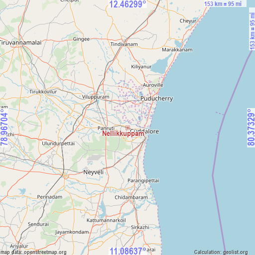
Nellikkuppam GPS coordinates[2]
11° 46' 31.944" North, 79° 40' 12.576" East
| Map corner | latitude | longitude |
|---|---|---|
| Upper-left | 12.46299°, | 78.96704° |
| Center: | 11.77554°, | 79.67016° |
| Lower-right: | 11.08637°, | 80.37329° |
| Map W x H: | 153.1×153.1 km | = 95.1×95.1mi |
| max Lat: | 34.9274° ⇑90.3% North |
| Nellikkuppam: | 11.77554° |
| min Lat: | ⇓9.7% South 8.09008° |
| min Long | Nellikkuppam | max Long |
| 68.82655° | 79.67016° | 96.81° |
| W 65.4%⇐ | ⇒34.6% E |
Elevation
Elevation of Nellikkuppam is 22 m = 72 ft, and this is 273.6 m = 898 ft below average elevation for this country.
| Max E: |
3681 m = 12077 ft | 88.1% |
| Avg. | 295.6 m = 970 ft | |
| Nellikkuppam | 22 m = 72 ft | |
Min E: |
1 m = 3 ft | 11.9% |
See also: Nellikkuppam elevation on elevation.city.
Geographical zone
Nellikkuppam is located in North Torrid zone (between Equator and Tropic of Cancer). Distance of this Northern Tropic circle is 1296.6 km =805.7 mi to North.| Distance of | km | miles | from Nellikkuppam |
|---|---|---|---|
| North Pole | 8697.7 | 5404.5 | to North |
| Arctic Circle | 6091.9 | 3785.3 | to North |
| Tropic Cancer | 1296.6 | 805.7 | to North |
| Equator | 1309.3 | 813.6 | to South |


Nearby cities:
15 places around Nellikkuppam: (largest is in red/bold)
• Annāmalainagar
42.3 km =26.3 mi,  170°
170°
• Auroville
29.7 km =18.5 mi,  30°
30°
• Chidambaram
41.9 km =26 mi,  176°
176°
• Cuddalore
10.8 km =6.7 mi,  101°
101°
• Kurinjippādi
26.5 km =16.5 mi,  199°
199°
• Kīl Bhuvanagiri
37.1 km =23.1 mi, 183°
• Panruti
12.8 km =8 mi,  270°
270°
• Puducherry
24.7 km =15.3 mi,  44°
44°
• Srīmushnam
50.7 km =31.5 mi,  214°
214°
• Tindivanam
51 km =31.7 mi,  358°
358°
• Valavanur
18.8 km =11.7 mi,  329°
329°
• Vikravāndi
32 km =19.9 mi,  335°
335°
• Villupuram
26.6 km =16.5 mi,  313°
313°
• Vriddhāchalam
47.3 km =29.4 mi,  232°
232°
• Ālappākkam
20.3 km =12.6 mi,  164°
164°
Sources, notices
• [Note1] Compared only with cities in India existing in our database
• [Src1] Map data: © OpenStreetMap contributors (CC-BY-SA)
• [Src2] Other city data from geonames.org with taken over terms of usage.
• [Src3] Geographical zone / Annual Mean Temperature by Robert A. Rohde @ Wikipedia
