Virudunagar geodata
Virudunagar (Tamil Nadu) is a populated place; located in India in Asia/Kolkata (GMT+5.5) time zone. With population of 73,273 people, there are 601 cities with bigger population in this country. Compared to other cities in India, 97.6% of cities are located further ↑North; 51.7% of cities are located further →East and 67.4% of cities have higher elevation than Virudunagar. Note1


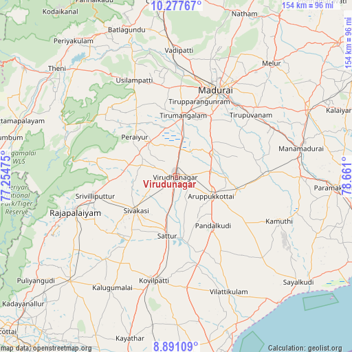
Virudunagar GPS coordinates[2]
9° 35' 6.324" North, 77° 57' 28.332" East
| Map corner | latitude | longitude |
|---|---|---|
| Upper-left | 10.27767°, | 77.25475° |
| Center: | 9.58509°, | 77.95787° |
| Lower-right: | 8.89109°, | 78.661° |
| Map W x H: | 154.2×154.2 km | = 95.8×95.8mi |
| max Lat: | 34.9274° ⇑97.6% North |
| Virudunagar: | 9.58509° |
| min Lat: | ⇓2.4% South 8.09008° |
| min Long | Virudunagar | max Long |
| 68.82655° | 77.95787° | 96.81° |
| W 48.3%⇐ | ⇒51.7% E |
Elevation
Elevation of Virudunagar is 105 m = 344 ft, and this is 190.6 m = 625 ft below average elevation for this country.
| Max E: |
3681 m = 12077 ft | 67.4% |
| Avg. | 295.6 m = 970 ft | |
| Virudunagar | 105 m = 344 ft | |
Min E: |
1 m = 3 ft | 32.6% |
See also: Virudunagar elevation on elevation.city.
Geographical zone
Virudunagar is located in North Torrid zone (between Equator and Tropic of Cancer). Distance of Equator is 1065.8 km =662.3 mi to South.| Distance of | km | miles | from Virudunagar |
|---|---|---|---|
| North Pole | 8941.3 | 5555.9 | to North |
| Arctic Circle | 6335.4 | 3936.6 | to North |
| Tropic Cancer | 1540.2 | 957 | to North |
| Equator | 1065.8 | 662.3 | to South |


Nearby cities:
15 places around Virudunagar: (largest is in red/bold)
• Aruppukkottai
17.3 km =10.7 mi,  119°
119°
• Elumalai
42.1 km =26.2 mi,  317°
317°
• Elāyirampannai
37.9 km =23.5 mi,  202°
202°
• Kallupatti
17.7 km =11 mi,  325°
325°
• Kariapatti
18.5 km =11.5 mi,  57°
57°
• Madurai
41.1 km =25.5 mi,  25°
25°
• Peraiyur
24.9 km =15.5 mi,  312°
312°
• Pudūr
38.2 km =23.7 mi,  148°
148°
• Rajapalaiyam
46.7 km =29 mi,  251°
251°
• Sattur
25.7 km =16 mi,  188°
188°
• Sivakasi
23.1 km =14.4 mi,  229°
229°
• Srivilliputhur
36.4 km =22.6 mi,  257°
257°
• Tirupparangunram
35.3 km =21.9 mi,  20°
20°
• Tiruppuvanam
42.4 km =26.3 mi,  50°
50°
• Tiruttangal
17.7 km =11 mi, 230°
Sources, notices
• [Note1] Compared only with cities in India existing in our database
• [Src1] Map data: © OpenStreetMap contributors (CC-BY-SA)
• [Src2] Other city data from geonames.org with taken over terms of usage.
• [Src3] Geographical zone / Annual Mean Temperature by Robert A. Rohde @ Wikipedia
