Peraiyur geodata
Peraiyur (Tamil Nadu) is a populated place; located in India in Asia/Kolkata (GMT+5.5) time zone. With population of 9,244 people, there are 3016 cities with bigger population in this country. Compared to other cities in India, 97.2% of cities are located further ↑North; 53.8% of cities are located further →East and 55.3% of cities have higher elevation than Peraiyur. Note1


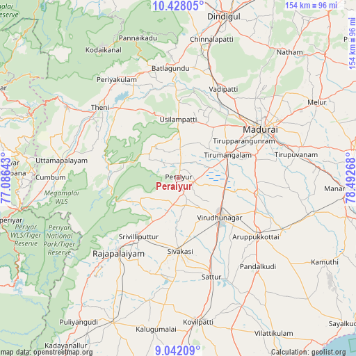
Peraiyur GPS coordinates[2]
9° 44' 8.844" North, 77° 47' 22.38" East
| Map corner | latitude | longitude |
|---|---|---|
| Upper-left | 10.42805°, | 77.08643° |
| Center: | 9.73579°, | 77.78955° |
| Lower-right: | 9.04209°, | 78.49268° |
| Map W x H: | 154.1×154.1 km | = 95.8×95.8mi |
| max Lat: | 34.9274° ⇑97.2% North |
| Peraiyur: | 9.73579° |
| min Lat: | ⇓2.8% South 8.09008° |
| min Long | Peraiyur | max Long |
| 68.82655° | 77.78955° | 96.81° |
| W 46.2%⇐ | ⇒53.8% E |
Elevation
Elevation of Peraiyur is 173 m = 568 ft, and this is 122.6 m = 402 ft below average elevation for this country.
| Max E: |
3681 m = 12077 ft | 55.3% |
| Avg. | 295.6 m = 970 ft | |
| Peraiyur | 173 m = 568 ft | |
Min E: |
1 m = 3 ft | 44.7% |
See also: India elevation on elevation.city.
Geographical zone
Peraiyur is located in North Torrid zone (between Equator and Tropic of Cancer). Distance of Equator is 1082.5 km =672.6 mi to South.| Distance of | km | miles | from Peraiyur |
|---|---|---|---|
| North Pole | 8924.5 | 5545.4 | to North |
| Arctic Circle | 6318.7 | 3926.3 | to North |
| Tropic Cancer | 1523.4 | 946.6 | to North |
| Equator | 1082.5 | 672.6 | to South |


Nearby cities:
15 places around Peraiyur: (largest is in red/bold)
• Aruppukkottai
42 km =26.1 mi,  126°
126°
• Elumalai
17.4 km =10.8 mi,  325°
325°
• Kallupatti
8.7 km =5.4 mi,  104°
104°
• Kariapatti
34.7 km =21.6 mi, 101°
• Madurai
41.5 km =25.8 mi,  60°
60°
• Rajapalaiyam
40.7 km =25.3 mi,  219°
219°
• Sattur
44.8 km =27.8 mi,  160°
160°
• Sivakasi
31.8 km =19.8 mi,  178°
178°
• Srivilliputhur
30.1 km =18.7 mi,  214°
214°
• Tirupparangunram
35 km =21.7 mi, 62°
• Tiruttangal
28.5 km =17.7 mi,  170°
170°
• Usilampatti
26 km =16.2 mi,  359°
359°
• Virudunagar
24.9 km =15.5 mi, 132°
• Vādippatti
43.1 km =26.8 mi,  25°
25°
• Āndippatti
34.5 km =21.4 mi, 327°
Sources, notices
• [Note1] Compared only with cities in India existing in our database
• [Src1] Map data: © OpenStreetMap contributors (CC-BY-SA)
• [Src2] Other city data from geonames.org with taken over terms of usage.
• [Src3] Geographical zone / Annual Mean Temperature by Robert A. Rohde @ Wikipedia
