Dūsi geodata
Dūsi (Tamil Nadu) is a populated place; located in India in Asia/Kolkata (GMT+5.5) time zone. With population of 5,257 people, there are 3328 cities with bigger population in this country. Compared to other cities in India, 87.5% of cities are located further ↑North; 65.5% of cities are located further ←West and 71% of cities have higher elevation than Dūsi. Note1


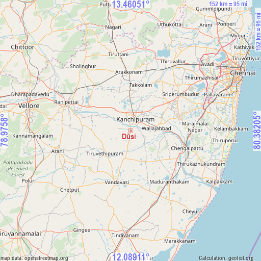
Dūsi GPS coordinates[2]
12° 46' 32.664" North, 79° 40' 44.112" East
| Map corner | latitude | longitude |
|---|---|---|
| Upper-left | 13.46051°, | 78.9758° |
| Center: | 12.77574°, | 79.67892° |
| Lower-right: | 12.08911°, | 80.38205° |
| Map W x H: | 152.5×152.5 km | = 94.8×94.8mi |
| max Lat: | 34.9274° ⇑87.5% North |
| Dūsi: | 12.77574° |
| min Lat: | ⇓12.5% South 8.09008° |
| min Long | Dūsi | max Long |
| 68.82655° | 79.67892° | 96.81° |
| W 65.5%⇐ | ⇒34.5% E |
Elevation
Elevation of Dūsi is 88 m = 289 ft, and this is 207.6 m = 681 ft below average elevation for this country.
| Max E: |
3681 m = 12077 ft | 71% |
| Avg. | 295.6 m = 970 ft | |
| Dūsi | 88 m = 289 ft | |
Min E: |
1 m = 3 ft | 29% |
See also: India elevation on elevation.city.
Geographical zone
Dūsi is located in North Torrid zone (between Equator and Tropic of Cancer). Distance of this Northern Tropic circle is 1185.4 km =736.6 mi to North.| Distance of | km | miles | from Dūsi |
|---|---|---|---|
| North Pole | 8586.5 | 5335.4 | to North |
| Arctic Circle | 5980.6 | 3716.2 | to North |
| Tropic Cancer | 1185.4 | 736.6 | to North |
| Equator | 1420.5 | 882.7 | to South |


Nearby cities:
15 places around Dūsi: (largest is in red/bold)
• Arakkonam
34.3 km =21.3 mi,  358°
358°
• Arcot
41.6 km =25.8 mi,  290°
290°
• Cheyyar
19.5 km =12.1 mi,  228°
228°
• Chingleput
33.6 km =20.9 mi,  106°
106°
• Kalavai
28.1 km =17.5 mi,  268°
268°
• Kanchipuram
7 km =4.3 mi,  19°
19°
• Madambakkam
40.8 km =25.4 mi,  77°
77°
• Madurāntakam
36.9 km =22.9 mi,  142°
142°
• Peranamallūr
35.1 km =21.8 mi, 229°
• Singapperumālkovil
35.7 km =22.2 mi,  92°
92°
• Srīperumbūdūr
35.6 km =22.1 mi,  53°
53°
• Uttiramerūr
19.9 km =12.4 mi,  154°
154°
• Vandavāsi
31.2 km =19.4 mi,  194°
194°
• Walajapet
37.7 km =23.4 mi,  296°
296°
• Wallajahbad
15.8 km =9.8 mi, 84°
Sources, notices
• [Note1] Compared only with cities in India existing in our database
• [Src1] Map data: © OpenStreetMap contributors (CC-BY-SA)
• [Src2] Other city data from geonames.org with taken over terms of usage.
• [Src3] Geographical zone / Annual Mean Temperature by Robert A. Rohde @ Wikipedia
