Wardha geodata
Wardha (Maharashtra) is a populated place; located in India in Asia/Kolkata (GMT+5.5) time zone. With population of 113,759 people, there are 388 cities with bigger population in this country. Compared to other cities in India, 62.8% of cities are located further ↑North; 55.2% of cities are located further ←West and 65.9% of cities have lower elevation than Wardha. Note1


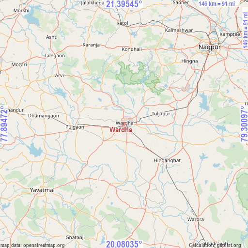
Wardha GPS coordinates[2]
20° 44' 21.588" North, 78° 35' 52.224" East
| Map corner | latitude | longitude |
|---|---|---|
| Upper-left | 21.39545°, | 77.89472° |
| Center: | 20.73933°, | 78.59784° |
| Lower-right: | 20.08035°, | 79.30097° |
| Map W x H: | 146.2×146.2 km | = 90.8×90.8mi |
| max Lat: | 34.9274° ⇑62.8% North |
| Wardha: | 20.73933° |
| min Lat: | ⇓37.2% South 8.09008° |
| min Long | Wardha | max Long |
| 68.82655° | 78.59784° | 96.81° |
| W 55.2%⇐ | ⇒44.8% E |
Elevation
Elevation of Wardha is 292 m = 958 ft, and this is 3.6 m = 12 ft below average elevation for this country.
| Max E: |
3681 m = 12077 ft | 34.1% |
| Avg. | 295.6 m = 970 ft | |
| Wardha | 292 m = 958 ft | |
Min E: |
1 m = 3 ft | 65.9% |
See also: Wardha elevation on elevation.city.
Geographical zone
Wardha is located in North Torrid zone (between Equator and Tropic of Cancer). Distance of this Northern Tropic circle is 299.9 km =186.3 mi to North.| Distance of | km | miles | from Wardha |
|---|---|---|---|
| North Pole | 7701.1 | 4785.2 | to North |
| Arctic Circle | 5095.2 | 3166 | to North |
| Tropic Cancer | 299.9 | 186.3 | to North |
| Equator | 2306 | 1432.9 | to South |


Nearby cities:
15 places around Wardha: (largest is in red/bold)
• Chāndūr
64.7 km =40.2 mi,  277°
277°
• Dattāpur
47.8 km =29.7 mi, 275°
• Deoli
15.8 km =9.8 mi,  230°
230°
• Ghātanji
72.7 km =45.2 mi,  204°
204°
• Hinganghāt
32.9 km =20.4 mi,  130°
130°
• Kalmeshwar
64.2 km =39.9 mi,  31°
31°
• Kātol
59.4 km =36.9 mi,  358°
358°
• Mohpa
67.9 km =42.2 mi,  20°
20°
• Nagpur
67.9 km =42.2 mi,  48°
48°
• Pulgaon
28.9 km =18 mi,  266°
266°
• Sindi
31 km =19.3 mi,  76°
76°
• Sonegaon
15.7 km =9.8 mi,  141°
141°
• Warora
70.7 km =43.9 mi, 143°
• Yavatmāl
61.9 km =38.5 mi, 231°
• Ārvi
47.8 km =29.7 mi,  306°
306°
Sources, notices
• [Note1] Compared only with cities in India existing in our database
• [Src1] Map data: © OpenStreetMap contributors (CC-BY-SA)
• [Src2] Other city data from geonames.org with taken over terms of usage.
• [Src3] Geographical zone / Annual Mean Temperature by Robert A. Rohde @ Wikipedia
