Ārvi geodata
Ārvi (Maharashtra) is a populated place; located in India in Asia/Kolkata (GMT+5.5) time zone. With population of 41,837 people, there are 1055 cities with bigger population in this country. Compared to other cities in India, 61.7% of cities are located further ↑North; 51.5% of cities are located further ←West and 67.8% of cities have lower elevation than Ārvi. Note1


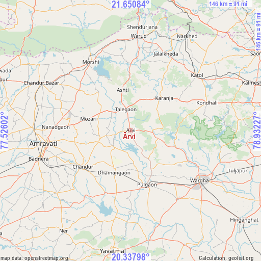
Ārvi GPS coordinates[2]
20° 59' 45.06" North, 78° 13' 44.904" East
| Map corner | latitude | longitude |
|---|---|---|
| Upper-left | 21.65084°, | 77.52602° |
| Center: | 20.99585°, | 78.22914° |
| Lower-right: | 20.33798°, | 78.93227° |
| Map W x H: | 146×146 km | = 90.7×90.7mi |
| max Lat: | 34.9274° ⇑61.7% North |
| Ārvi: | 20.99585° |
| min Lat: | ⇓38.3% South 8.09008° |
| min Long | Ārvi | max Long |
| 68.82655° | 78.22914° | 96.81° |
| W 51.5%⇐ | ⇒48.5% E |
Elevation
Elevation of Ārvi is 307 m = 1007 ft, and this is 11.4 m = 37 ft above average elevation for this country.
| Max E: |
3681 m = 12077 ft | 32.2% |
| Ārvi | 307 m 1007 ft | |
| Avg. | 295.6 m = 970 ft | |
Min E: |
1 m = 3 ft | 67.8% |
See also: Ārvi elevation on elevation.city.
Geographical zone
Ārvi is located in North Torrid zone (between Equator and Tropic of Cancer). Distance of this Northern Tropic circle is 271.4 km =168.6 mi to North.| Distance of | km | miles | from Ārvi |
|---|---|---|---|
| North Pole | 7672.5 | 4767.5 | to North |
| Arctic Circle | 5066.7 | 3148.3 | to North |
| Tropic Cancer | 271.4 | 168.6 | to North |
| Equator | 2334.5 | 1450.6 | to South |


Nearby cities:
15 places around Ārvi: (largest is in red/bold)
• Amrāvati
50.2 km =31.2 mi,  262°
262°
• Chāndūr
32.8 km =20.4 mi,  231°
231°
• Chāndūr Bāzār
56.8 km =35.3 mi,  298°
298°
• Dattāpur
25.6 km =15.9 mi,  201°
201°
• Deoli
46.5 km =28.9 mi,  145°
145°
• Kātol
48.2 km =30 mi,  50°
50°
• Mohpa
71.4 km =44.4 mi,  60°
60°
• Morsi
44.4 km =27.6 mi,  329°
329°
• Mowād
57 km =35.4 mi,  23°
23°
• Pulgaon
31.9 km =19.8 mi,  162°
162°
• Sindi
71.6 km =44.5 mi,  107°
107°
• Sonegaon
63.1 km =39.2 mi,  130°
130°
• Wardha
47.8 km =29.7 mi, 126°
• Warud
53 km =32.9 mi,  4°
4°
• Yavatmāl
67.8 km =42.1 mi,  188°
188°
Sources, notices
• [Note1] Compared only with cities in India existing in our database
• [Src1] Map data: © OpenStreetMap contributors (CC-BY-SA)
• [Src2] Other city data from geonames.org with taken over terms of usage.
• [Src3] Geographical zone / Annual Mean Temperature by Robert A. Rohde @ Wikipedia
