Yavatmāl geodata
Yavatmāl (Maharashtra) is a populated place; located in India in Asia/Kolkata (GMT+5.5) time zone. With population of 128,175 people, there are 341 cities with bigger population in this country. Compared to other cities in India, 63.9% of cities are located further ↑North; 50.3% of cities are located further ←West and 79.1% of cities have lower elevation than Yavatmāl. Note1


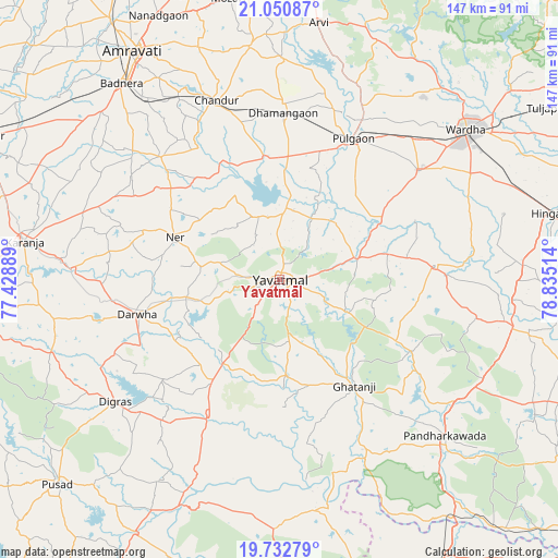
Yavatmāl GPS coordinates[2]
20° 23' 35.664" North, 78° 7' 55.236" East
| Map corner | latitude | longitude |
|---|---|---|
| Upper-left | 21.05087°, | 77.42889° |
| Center: | 20.39324°, | 78.13201° |
| Lower-right: | 19.73279°, | 78.83514° |
| Map W x H: | 146.6×146.6 km | = 91.1×91.1mi |
| max Lat: | 34.9274° ⇑63.9% North |
| Yavatmāl: | 20.39324° |
| min Lat: | ⇓36.1% South 8.09008° |
| min Long | Yavatmāl | max Long |
| 68.82655° | 78.13201° | 96.81° |
| W 50.3%⇐ | ⇒49.7% E |
Elevation
Elevation of Yavatmāl is 446 m = 1463 ft, and this is 150.4 m = 493 ft above average elevation for this country.
| Max E: |
3681 m = 12077 ft | 20.9% |
| Yavatmāl | 446 m 1463 ft | |
| Avg. | 295.6 m = 970 ft | |
Min E: |
1 m = 3 ft | 79.1% |
See also: Yavatmāl elevation on elevation.city.
Geographical zone
Yavatmāl is located in North Torrid zone (between Equator and Tropic of Cancer). Distance of this Northern Tropic circle is 338.4 km =210.3 mi to North.| Distance of | km | miles | from Yavatmāl |
|---|---|---|---|
| North Pole | 7739.5 | 4809.1 | to North |
| Arctic Circle | 5133.7 | 3189.9 | to North |
| Tropic Cancer | 338.4 | 210.3 | to North |
| Equator | 2267.5 | 1409 | to South |


Nearby cities:
15 places around Yavatmāl: (largest is in red/bold)
• Amrāvati
72 km =44.7 mi,  326°
326°
• Chāndūr
49.4 km =30.7 mi,  341°
341°
• Dattāpur
43.1 km =26.8 mi,  1°
1°
• Deoli
46.1 km =28.6 mi,  51°
51°
• Digras
53.8 km =33.4 mi,  233°
233°
• Dārwha
38.6 km =24 mi,  256°
256°
• Ghātanji
33.8 km =21 mi,  145°
145°
• Hinganghāt
75.7 km =47 mi,  76°
76°
• Kāranja
67.8 km =42.1 mi,  278°
278°
• Mangrūl Pīr
82.9 km =51.5 mi, 263°
• Pulgaon
41.5 km =25.8 mi,  28°
28°
• Pusad
78.7 km =48.9 mi, 227°
• Sonegaon
64 km =39.8 mi,  65°
65°
• Wardha
61.9 km =38.5 mi, 51°
• Ārvi
67.8 km =42.1 mi,  8°
8°
Sources, notices
• [Note1] Compared only with cities in India existing in our database
• [Src1] Map data: © OpenStreetMap contributors (CC-BY-SA)
• [Src2] Other city data from geonames.org with taken over terms of usage.
• [Src3] Geographical zone / Annual Mean Temperature by Robert A. Rohde @ Wikipedia
