Tawang geodata
Tawang (Arunachal Pradesh) is a populated place; located in India in Asia/Kolkata (GMT+5.5) time zone. With population of 4,831 people, there are 3348 cities with bigger population in this country. Compared to other cities in India, 82.4% of cities are located further ↓South; 96.9% of cities are located further ←West and 99.7% of cities have lower elevation than Tawang. Note1


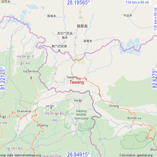
Tawang GPS coordinates[2]
27° 34' 27.012" North, 91° 55' 27.732" East
| Map corner | latitude | longitude |
|---|---|---|
| Upper-left | 28.19565°, | 91.22125° |
| Center: | 27.57417°, | 91.92437° |
| Lower-right: | 26.94915°, | 92.6275° |
| Map W x H: | 138.6×138.6 km | = 86.1×86.1mi |
| max Lat: | 34.9274° ⇑17.6% North |
| Tawang: | 27.57417° |
| min Lat: | ⇓82.4% South 8.09008° |
| min Long | Tawang | max Long |
| 68.82655° | 91.92437° | 96.81° |
| W 96.9%⇐ | ⇒3.1% E |
Elevation
Elevation of Tawang is 2432 m = 7979 ft, and this is 2136.4 m = 7009 ft above average elevation for this country.
| Max E: |
3681 m = 12077 ft | 0.3% |
| Tawang | 2432 m 7979 ft | |
| Avg. | 295.6 m = 970 ft | |
Min E: |
1 m = 3 ft | 99.7% |
See also: India elevation on elevation.city.
Geographical zone
Tawang is located in North temperate zone (between Tropic of Cancer and the Arctic Circle). Distance of this Northern Tropic circle is 460 km =285.8 mi to South.| Distance of | km | miles | from Tawang |
|---|---|---|---|
| North Pole | 6941.1 | 4313 | to North |
| Arctic Circle | 4335.2 | 2693.8 | to North |
| Tropic Cancer | 460 | 285.8 | to South |
| Equator | 3066 | 1905.1 | to South |


Nearby cities:
15 places around Tawang: (largest is in red/bold)
• Barpeta Road
152.1 km =94.5 mi,  218°
218°
• Biswanath Chariali
153.4 km =95.3 mi,  127°
127°
• Bomdila
60.2 km =37.4 mi,  124°
124°
• Dhekiajuli
111.2 km =69.1 mi,  150°
150°
• Dhing
134.5 km =83.6 mi,  156°
156°
• Hājo
153 km =95.1 mi,  194°
194°
• Khārupatia
119.4 km =74.2 mi,  169°
169°
• Mangaldai
126.3 km =78.5 mi,  175°
175°
• Morigaon
153.2 km =95.2 mi, 164°
• Mushalpur
121.1 km =75.2 mi,  204°
204°
• North Guwāhāti
154.4 km =95.9 mi, 187°
• Rangia
128.8 km =80 mi, 193°
• Rangāpāra
110.1 km =68.4 mi,  138°
138°
• Tezpur
135.8 km =84.4 mi, 140°
• Udalguri
92.9 km =57.7 mi, 169°
Sources, notices
• [Note1] Compared only with cities in India existing in our database
• [Src1] Map data: © OpenStreetMap contributors (CC-BY-SA)
• [Src2] Other city data from geonames.org with taken over terms of usage.
• [Src3] Geographical zone / Annual Mean Temperature by Robert A. Rohde @ Wikipedia
