Itānagar geodata
Itānagar (Arunachal Pradesh) is a seat of a first-order administrative division; located in India in Asia/Kolkata (GMT+5.5) time zone. With population of 44,971 people, there are 986 cities with bigger population in this country. Compared to other cities in India, 79.1% of cities are located further ↓South; 98.2% of cities are located further ←West and 69.9% of cities have lower elevation than Itānagar. Note1


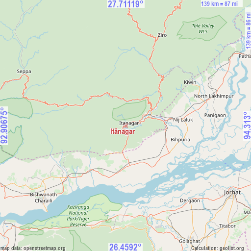
Itānagar GPS coordinates[2]
27° 5' 12.984" North, 93° 36' 35.532" East
| Map corner | latitude | longitude |
|---|---|---|
| Upper-left | 27.71119°, | 92.90675° |
| Center: | 27.08694°, | 93.60987° |
| Lower-right: | 26.4592°, | 94.313° |
| Map W x H: | 139.2×139.2 km | = 86.5×86.5mi |
| max Lat: | 34.9274° ⇑20.9% North |
| Itānagar: | 27.08694° |
| min Lat: | ⇓79.1% South 8.09008° |
| min Long | Itānagar | max Long |
| 68.82655° | 93.60987° | 96.81° |
| W 98.2%⇐ | ⇒1.8% E |
Elevation
Elevation of Itānagar is 326 m = 1070 ft, and this is 30.4 m = 100 ft above average elevation for this country.
| Max E: |
3681 m = 12077 ft | 30.1% |
| Itānagar | 326 m 1070 ft | |
| Avg. | 295.6 m = 970 ft | |
Min E: |
1 m = 3 ft | 69.9% |
See also: Itānagar elevation on elevation.city.
Geographical zone
Itānagar is located in North temperate zone (between Tropic of Cancer and the Arctic Circle). Distance of this Northern Tropic circle is 405.9 km =252.2 mi to South.| Distance of | km | miles | from Itānagar |
|---|---|---|---|
| North Pole | 6995.3 | 4346.7 | to North |
| Arctic Circle | 4389.4 | 2727.4 | to North |
| Tropic Cancer | 405.9 | 252.2 | to South |
| Equator | 3011.8 | 1871.4 | to South |


Nearby cities:
15 places around Itānagar: (largest is in red/bold)
• Barpathār
93.1 km =57.8 mi,  162°
162°
• Bihpuriāgaon
31.4 km =19.5 mi,  104°
104°
• Biswanath Chariali
61 km =37.9 mi,  228°
228°
• Bokākhāt
49.7 km =30.9 mi,  181°
181°
• Dergaon
55.7 km =34.6 mi,  140°
140°
• Garamur
57.8 km =35.9 mi,  105°
105°
• Gohpur
22.8 km =14.2 mi, 178°
• Golāghāt
72.8 km =45.2 mi,  151°
151°
• Jorhāt
69.3 km =43.1 mi,  121°
121°
• Mariāni
84.7 km =52.6 mi, 124°
• Naharlagun
8.7 km =5.4 mi,  76°
76°
• North Lakhimpur
51.5 km =32 mi,  71°
71°
• Numāligarh
52.8 km =32.8 mi,  167°
167°
• Titābar
79.9 km =49.6 mi,  132°
132°
• Ziro
60.8 km =37.8 mi,  21°
21°
Sources, notices
• [Note1] Compared only with cities in India existing in our database
• [Src1] Map data: © OpenStreetMap contributors (CC-BY-SA)
• [Src2] Other city data from geonames.org with taken over terms of usage.
• [Src3] Geographical zone / Annual Mean Temperature by Robert A. Rohde @ Wikipedia
