Bisauli geodata
Bisauli (Uttar Pradesh) is a populated place; located in India in Asia/Kolkata (GMT+5.5) time zone. With population of 32,154 people, there are 1352 cities with bigger population in this country. Compared to other cities in India, 86% of cities are located further ↓South; 58.4% of cities are located further ←West and 52.8% of cities have higher elevation than Bisauli. Note1


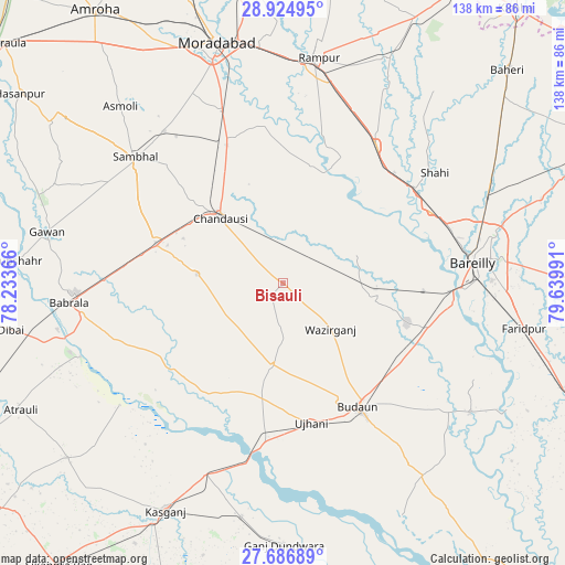
Bisauli GPS coordinates[2]
28° 18' 27.792" North, 78° 56' 12.408" East
| Map corner | latitude | longitude |
|---|---|---|
| Upper-left | 28.92495°, | 78.23366° |
| Center: | 28.30772°, | 78.93678° |
| Lower-right: | 27.68689°, | 79.63991° |
| Map W x H: | 137.7×137.7 km | = 85.6×85.6mi |
| max Lat: | 34.9274° ⇑14% North |
| Bisauli: | 28.30772° |
| min Lat: | ⇓86% South 8.09008° |
| min Long | Bisauli | max Long |
| 68.82655° | 78.93678° | 96.81° |
| W 58.4%⇐ | ⇒41.6% E |
Elevation
Elevation of Bisauli is 185 m = 607 ft, and this is 110.6 m = 363 ft below average elevation for this country.
| Max E: |
3681 m = 12077 ft | 52.8% |
| Avg. | 295.6 m = 970 ft | |
| Bisauli | 185 m = 607 ft | |
Min E: |
1 m = 3 ft | 47.2% |
See also: India elevation on elevation.city.
Geographical zone
Bisauli is located in North temperate zone (between Tropic of Cancer and the Arctic Circle). Distance of this Northern Tropic circle is 541.6 km =336.5 mi to South.| Distance of | km | miles | from Bisauli |
|---|---|---|---|
| North Pole | 6859.5 | 4262.3 | to North |
| Arctic Circle | 4253.7 | 2643.1 | to North |
| Tropic Cancer | 541.6 | 336.5 | to South |
| Equator | 3147.5 | 1955.8 | to South |


Nearby cities:
15 places around Bisauli: (largest is in red/bold)
• Aonla
22.7 km =14.1 mi,  99°
99°
• Bahjoi
31.9 km =19.8 mi,  287°
287°
• Bilsi
20 km =12.4 mi,  187°
187°
• Bilāri
37.2 km =23.1 mi,  339°
339°
• Budaun
35.3 km =21.9 mi,  148°
148°
• Chanduasi
22 km =13.7 mi,  316°
316°
• Fatehganj West
40.2 km =25 mi,  64°
64°
• Islāmnagar
20.8 km =12.9 mi,  276°
276°
• Mīrganj
37 km =23 mi,  45°
45°
• Narauli
29.4 km =18.3 mi,  312°
312°
• Sahaswān
31.9 km =19.8 mi,  214°
214°
• Sarauli
25.7 km =16 mi,  36°
36°
• Shāhābād
29.7 km =18.5 mi,  13°
13°
• Ujhāni
34.6 km =21.5 mi,  168°
168°
• Wazīrganj
15.9 km =9.9 mi,  132°
132°
Sources, notices
• [Note1] Compared only with cities in India existing in our database
• [Src1] Map data: © OpenStreetMap contributors (CC-BY-SA)
• [Src2] Other city data from geonames.org with taken over terms of usage.
• [Src3] Geographical zone / Annual Mean Temperature by Robert A. Rohde @ Wikipedia
