Ujhāni geodata
Ujhāni (Uttar Pradesh) is a populated place; located in India in Asia/Kolkata (GMT+5.5) time zone. With population of 56,309 people, there are 788 cities with bigger population in this country. Compared to other cities in India, 84.5% of cities are located further ↓South; 59.1% of cities are located further ←West and 55.3% of cities have higher elevation than Ujhāni. Note1


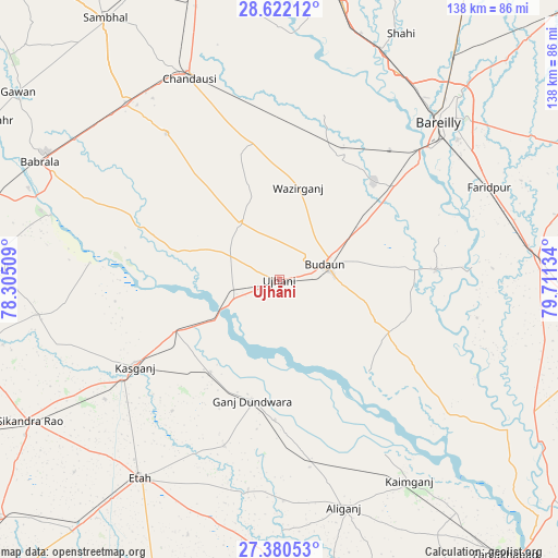
Ujhāni GPS coordinates[2]
28° 0' 11.196" North, 79° 0' 29.556" East
| Map corner | latitude | longitude |
|---|---|---|
| Upper-left | 28.62212°, | 78.30509° |
| Center: | 28.00311°, | 79.00821° |
| Lower-right: | 27.38053°, | 79.71134° |
| Map W x H: | 138.1×138.1 km | = 85.8×85.8mi |
| max Lat: | 34.9274° ⇑15.5% North |
| Ujhāni: | 28.00311° |
| min Lat: | ⇓84.5% South 8.09008° |
| min Long | Ujhāni | max Long |
| 68.82655° | 79.00821° | 96.81° |
| W 59.1%⇐ | ⇒40.9% E |
Elevation
Elevation of Ujhāni is 173 m = 568 ft, and this is 122.6 m = 402 ft below average elevation for this country.
| Max E: |
3681 m = 12077 ft | 55.3% |
| Avg. | 295.6 m = 970 ft | |
| Ujhāni | 173 m = 568 ft | |
Min E: |
1 m = 3 ft | 44.7% |
See also: Ujhāni elevation on elevation.city.
Geographical zone
Ujhāni is located in North temperate zone (between Tropic of Cancer and the Arctic Circle). Distance of this Northern Tropic circle is 507.7 km =315.5 mi to South.| Distance of | km | miles | from Ujhāni |
|---|---|---|---|
| North Pole | 6893.4 | 4283.4 | to North |
| Arctic Circle | 4287.5 | 2664.1 | to North |
| Tropic Cancer | 507.7 | 315.5 | to South |
| Equator | 3113.7 | 1934.8 | to South |


Nearby cities:
15 places around Ujhāni: (largest is in red/bold)
• Amānpur
41.9 km =26 mi,  219°
219°
• Aonla
33.8 km =21 mi,  27°
27°
• Bilsi
17 km =10.6 mi,  325°
325°
• Bisauli
34.6 km =21.5 mi,  348°
348°
• Budaun
12.3 km =7.6 mi,  71°
71°
• Dātāganj
39.3 km =24.4 mi,  86°
86°
• Ganj Dundwāra
30.7 km =19.1 mi,  192°
192°
• Kakrāla
22 km =13.7 mi,  123°
123°
• Kāsganj
41.7 km =25.9 mi,  238°
238°
• Patiāli
34.7 km =21.6 mi,  181°
181°
• Sahaswān
26.4 km =16.4 mi,  286°
286°
• Sahāwar
28.7 km =17.8 mi, 216°
• Soron
28.6 km =17.8 mi, 244°
• Usehat
32.1 km =19.9 mi,  135°
135°
• Wazīrganj
23.6 km =14.7 mi,  11°
11°
Sources, notices
• [Note1] Compared only with cities in India existing in our database
• [Src1] Map data: © OpenStreetMap contributors (CC-BY-SA)
• [Src2] Other city data from geonames.org with taken over terms of usage.
• [Src3] Geographical zone / Annual Mean Temperature by Robert A. Rohde @ Wikipedia
