Fatehganj West geodata
Fatehganj West (Uttar Pradesh) is a populated place; located in India in Asia/Kolkata (GMT+5.5) time zone. With population of 23,810 people, there are 1782 cities with bigger population in this country. Compared to other cities in India, 86.7% of cities are located further ↓South; 61.8% of cities are located further ←West and 55.6% of cities have higher elevation than Fatehganj West. Note1


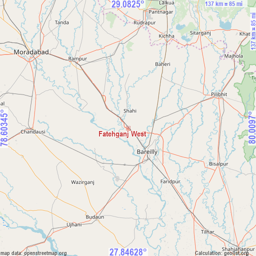
Fatehganj West GPS coordinates[2]
28° 27' 58.32" North, 79° 18' 23.652" East
| Map corner | latitude | longitude |
|---|---|---|
| Upper-left | 29.0825°, | 78.60345° |
| Center: | 28.4662°, | 79.30657° |
| Lower-right: | 27.84628°, | 80.0097° |
| Map W x H: | 137.5×137.5 km | = 85.4×85.4mi |
| max Lat: | 34.9274° ⇑13.3% North |
| Fatehganj West: | 28.4662° |
| min Lat: | ⇓86.7% South 8.09008° |
| min Long | Fatehganj West | max Long |
| 68.82655° | 79.30657° | 96.81° |
| W 61.8%⇐ | ⇒38.2% E |
Elevation
Elevation of Fatehganj West is 172 m = 564 ft, and this is 123.6 m = 406 ft below average elevation for this country.
| Max E: |
3681 m = 12077 ft | 55.6% |
| Avg. | 295.6 m = 970 ft | |
| Fatehganj West | 172 m = 564 ft | |
Min E: |
1 m = 3 ft | 44.4% |
See also: India elevation on elevation.city.
Geographical zone
Fatehganj West is located in North temperate zone (between Tropic of Cancer and the Arctic Circle). Distance of this Northern Tropic circle is 559.2 km =347.5 mi to South.| Distance of | km | miles | from Fatehganj West |
|---|---|---|---|
| North Pole | 6841.9 | 4251.4 | to North |
| Arctic Circle | 4236 | 2632.1 | to North |
| Tropic Cancer | 559.2 | 347.5 | to South |
| Equator | 3165.1 | 1966.7 | to South |


Nearby cities:
15 places around Fatehganj West: (largest is in red/bold)
• Aonla
25.5 km =15.8 mi,  212°
212°
• Baheri
39 km =24.2 mi,  28°
28°
• Bareilly
16.5 km =10.3 mi,  132°
132°
• Deoraniān
24.6 km =15.3 mi,  42°
42°
• Farīdpur
36.6 km =22.7 mi,  141°
141°
• Milak
20.9 km =13 mi,  320°
320°
• Mīrganj
12.6 km =7.8 mi,  310°
310°
• Nawābganj
33.1 km =20.6 mi,  75°
75°
• Richha
33 km =20.5 mi, 39°
• Sarauli
21.2 km =13.2 mi,  278°
278°
• Shergarh
21.4 km =13.3 mi,  16°
16°
• Shāhi
9.4 km =5.8 mi,  6°
6°
• Shāhābād
31.1 km =19.3 mi,  291°
291°
• Shīshgarh
29.3 km =18.2 mi,  1°
1°
• Wazīrganj
37.4 km =23.2 mi,  220°
220°
Sources, notices
• [Note1] Compared only with cities in India existing in our database
• [Src1] Map data: © OpenStreetMap contributors (CC-BY-SA)
• [Src2] Other city data from geonames.org with taken over terms of usage.
• [Src3] Geographical zone / Annual Mean Temperature by Robert A. Rohde @ Wikipedia
