Chanduasi geodata
Chanduasi (Uttar Pradesh) is a populated place; located in India in Asia/Kolkata (GMT+5.5) time zone. With population of 112,635 people, there are 391 cities with bigger population in this country. Compared to other cities in India, 86.6% of cities are located further ↓South; 56.7% of cities are located further ←West and 51.7% of cities have higher elevation than Chanduasi. Note1


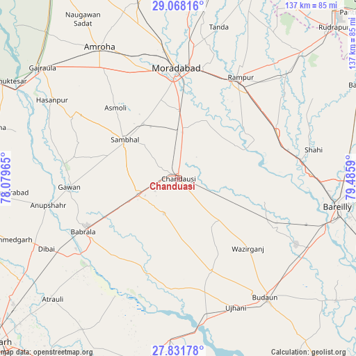
Chanduasi GPS coordinates[2]
28° 27' 6.408" North, 78° 46' 57.972" East
| Map corner | latitude | longitude |
|---|---|---|
| Upper-left | 29.06816°, | 78.07965° |
| Center: | 28.45178°, | 78.78277° |
| Lower-right: | 27.83178°, | 79.4859° |
| Map W x H: | 137.5×137.5 km | = 85.4×85.4mi |
| max Lat: | 34.9274° ⇑13.4% North |
| Chanduasi: | 28.45178° |
| min Lat: | ⇓86.6% South 8.09008° |
| min Long | Chanduasi | max Long |
| 68.82655° | 78.78277° | 96.81° |
| W 56.7%⇐ | ⇒43.3% E |
Elevation
Elevation of Chanduasi is 193 m = 633 ft, and this is 102.6 m = 337 ft below average elevation for this country.
| Max E: |
3681 m = 12077 ft | 51.7% |
| Avg. | 295.6 m = 970 ft | |
| Chanduasi | 193 m = 633 ft | |
Min E: |
1 m = 3 ft | 48.3% |
See also: Chanduasi elevation on elevation.city.
Geographical zone
Chanduasi is located in North temperate zone (between Tropic of Cancer and the Arctic Circle). Distance of this Northern Tropic circle is 557.6 km =346.5 mi to South.| Distance of | km | miles | from Chanduasi |
|---|---|---|---|
| North Pole | 6843.5 | 4252.4 | to North |
| Arctic Circle | 4237.6 | 2633.1 | to North |
| Tropic Cancer | 557.6 | 346.5 | to South |
| Equator | 3163.5 | 1965.7 | to South |


Nearby cities:
15 places around Chanduasi: (largest is in red/bold)
• Aonla
42.3 km =26.3 mi,  117°
117°
• Bahjoi
16.5 km =10.3 mi,  247°
247°
• Bilsi
38 km =23.6 mi,  160°
160°
• Bilāri
19 km =11.8 mi,  6°
6°
• Bisauli
22 km =13.7 mi,  136°
136°
• Gunnaur
41 km =25.5 mi,  234°
234°
• Islāmnagar
14.8 km =9.2 mi,  202°
202°
• Kundarkhi
25.7 km =16 mi,  0°
0°
• Milak
41.7 km =25.9 mi,  65°
65°
• Narauli
7.6 km =4.7 mi,  299°
299°
• Sambhal
25.6 km =15.9 mi,  305°
305°
• Sarauli
30.6 km =19 mi,  81°
81°
• Shāhābād
25.6 km =15.9 mi,  60°
60°
• Sirsi
24.9 km =15.5 mi,  326°
326°
• Wazīrganj
37.8 km =23.5 mi,  134°
134°
Sources, notices
• [Note1] Compared only with cities in India existing in our database
• [Src1] Map data: © OpenStreetMap contributors (CC-BY-SA)
• [Src2] Other city data from geonames.org with taken over terms of usage.
• [Src3] Geographical zone / Annual Mean Temperature by Robert A. Rohde @ Wikipedia
