Vepagunta geodata
Vepagunta (Andhra Pradesh) is a populated place; located in India in Asia/Kolkata (GMT+5.5) time zone. With population of 26,881 people, there are 1590 cities with bigger population in this country. Compared to other cities in India, 72.3% of cities are located further ↑North; 80% of cities are located further ←West and 78.3% of cities have higher elevation than Vepagunta. Note1


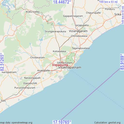
Vepagunta GPS coordinates[2]
17° 46' 42.384" North, 83° 12' 56.772" East
| Map corner | latitude | longitude |
|---|---|---|
| Upper-left | 18.44672°, | 82.51265° |
| Center: | 17.77844°, | 83.21577° |
| Lower-right: | 17.10765°, | 83.9189° |
| Map W x H: | 148.9×148.9 km | = 92.5×92.5mi |
| max Lat: | 34.9274° ⇑72.3% North |
| Vepagunta: | 17.77844° |
| min Lat: | ⇓27.7% South 8.09008° |
| min Long | Vepagunta | max Long |
| 68.82655° | 83.21577° | 96.81° |
| W 80%⇐ | ⇒20% E |
Elevation
Elevation of Vepagunta is 54 m = 177 ft, and this is 241.6 m = 793 ft below average elevation for this country.
| Max E: |
3681 m = 12077 ft | 78.3% |
| Avg. | 295.6 m = 970 ft | |
| Vepagunta | 54 m = 177 ft | |
Min E: |
1 m = 3 ft | 21.7% |
See also: India elevation on elevation.city.
Geographical zone
Vepagunta is located in North Torrid zone (between Equator and Tropic of Cancer). Distance of this Northern Tropic circle is 629.1 km =390.9 mi to North.| Distance of | km | miles | from Vepagunta |
|---|---|---|---|
| North Pole | 8030.3 | 4989.8 | to North |
| Arctic Circle | 5424.4 | 3370.6 | to North |
| Tropic Cancer | 629.1 | 390.9 | to North |
| Equator | 1976.8 | 1228.3 | to South |


Nearby cities:
15 places around Vepagunta: (largest is in red/bold)
• Akasahebpet
75.3 km =46.8 mi,  246°
246°
• Anakāpalle
24.4 km =15.2 mi, 246°
• Bhīmunipatnam
27.9 km =17.3 mi,  63°
63°
• Chodavaram
30.2 km =18.8 mi,  280°
280°
• Chīpurupalle
70 km =43.5 mi,  32°
32°
• Elamanchili
45.7 km =28.4 mi,  236°
236°
• Etikoppāka
59.8 km =37.2 mi, 238°
• Gajuwaka
8.7 km =5.4 mi,  179°
179°
• Mādugula
45 km =28 mi,  289°
289°
• Narsīpatnam
65.1 km =40.5 mi,  259°
259°
• Sālūr
82.1 km =51 mi,  359°
359°
• Tuni
84.9 km =52.8 mi, 236°
• Visakhapatnam
11 km =6.8 mi,  187°
187°
• Vizianagaram
43 km =26.7 mi, 28°
• Yārāda
14.7 km =9.1 mi,  155°
155°
Sources, notices
• [Note1] Compared only with cities in India existing in our database
• [Src1] Map data: © OpenStreetMap contributors (CC-BY-SA)
• [Src2] Other city data from geonames.org with taken over terms of usage.
• [Src3] Geographical zone / Annual Mean Temperature by Robert A. Rohde @ Wikipedia
