Beliātor geodata
Beliātor (West Bengal) is a populated place; located in India in Asia/Kolkata (GMT+5.5) time zone. With population of 6,014 people, there are 3289 cities with bigger population in this country. Compared to other cities in India, 53.7% of cities are located further ↓South; 89.6% of cities are located further ←West and 71.2% of cities have higher elevation than Beliātor. Note1


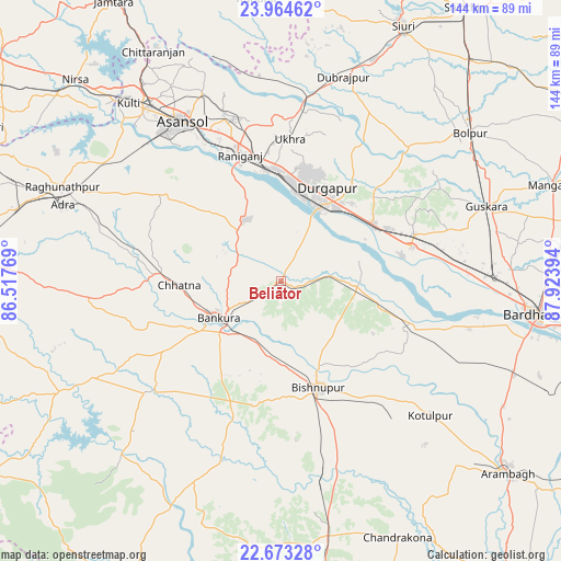
Beliātor GPS coordinates[2]
23° 19' 13.872" North, 87° 13' 14.916" East
| Map corner | latitude | longitude |
|---|---|---|
| Upper-left | 23.96462°, | 86.51769° |
| Center: | 23.32052°, | 87.22081° |
| Lower-right: | 22.67328°, | 87.92394° |
| Map W x H: | 143.6×143.6 km | = 89.2×89.2mi |
| max Lat: | 34.9274° ⇑46.3% North |
| Beliātor: | 23.32052° |
| min Lat: | ⇓53.7% South 8.09008° |
| min Long | Beliātor | max Long |
| 68.82655° | 87.22081° | 96.81° |
| W 89.6%⇐ | ⇒10.4% E |
Elevation
Elevation of Beliātor is 87 m = 285 ft, and this is 208.6 m = 684 ft below average elevation for this country.
| Max E: |
3681 m = 12077 ft | 71.2% |
| Avg. | 295.6 m = 970 ft | |
| Beliātor | 87 m = 285 ft | |
Min E: |
1 m = 3 ft | 28.8% |
See also: India elevation on elevation.city.
Geographical zone
Beliātor is located in North Torrid zone (between Equator and Tropic of Cancer). Distance of this Northern Tropic circle is 12.9 km =8 mi to North.| Distance of | km | miles | from Beliātor |
|---|---|---|---|
| North Pole | 7414.1 | 4606.9 | to North |
| Arctic Circle | 4808.2 | 2987.7 | to North |
| Tropic Cancer | 12.9 | 8 | to North |
| Equator | 2593 | 1611.2 | to South |


Nearby cities:
15 places around Beliātor: (largest is in red/bold)
• Adra
58.2 km =36.2 mi,  289°
289°
• Bahula
37.3 km =23.2 mi,  351°
351°
• Barjora
13.9 km =8.6 mi,  30°
30°
• Bishnupur
29.2 km =18.1 mi,  159°
159°
• Bānkura
18.1 km =11.2 mi,  237°
237°
• Dubrājpur
54.6 km =33.9 mi,  16°
16°
• Durgapur
23.5 km =14.6 mi, 22°
• Guskhara
55.8 km =34.7 mi,  69°
69°
• Jāmuria
45.1 km =28 mi,  341°
341°
• Khātra
53.6 km =33.3 mi,  224°
224°
• Pātrasāer
34.7 km =21.6 mi,  113°
113°
• Rānīganj
34.2 km =21.3 mi, 344°
• Sonāmukhi
19.7 km =12.2 mi,  94°
94°
• Āmlāgora
54 km =33.6 mi,  167°
167°
• Āsansol
47.1 km =29.3 mi,  329°
329°
Sources, notices
• [Note1] Compared only with cities in India existing in our database
• [Src1] Map data: © OpenStreetMap contributors (CC-BY-SA)
• [Src2] Other city data from geonames.org with taken over terms of usage.
• [Src3] Geographical zone / Annual Mean Temperature by Robert A. Rohde @ Wikipedia
