Guskhara geodata
Guskhara (West Bengal) is a populated place; located in India in Asia/Kolkata (GMT+5.5) time zone. With population of 33,780 people, there are 1285 cities with bigger population in this country. Compared to other cities in India, 54.8% of cities are located further ↓South; 90.6% of cities are located further ←West and 81.9% of cities have higher elevation than Guskhara. Note1


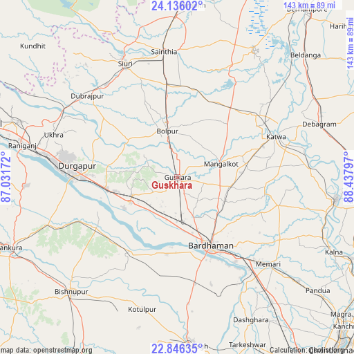
Guskhara GPS coordinates[2]
23° 29' 33.936" North, 87° 44' 5.424" East
| Map corner | latitude | longitude |
|---|---|---|
| Upper-left | 24.13602°, | 87.03172° |
| Center: | 23.49276°, | 87.73484° |
| Lower-right: | 22.84635°, | 88.43797° |
| Map W x H: | 143.4×143.4 km | = 89.1×89.1mi |
| max Lat: | 34.9274° ⇑45.2% North |
| Guskhara: | 23.49276° |
| min Lat: | ⇓54.8% South 8.09008° |
| min Long | Guskhara | max Long |
| 68.82655° | 87.73484° | 96.81° |
| W 90.6%⇐ | ⇒9.4% E |
Elevation
Elevation of Guskhara is 41 m = 135 ft, and this is 254.6 m = 835 ft below average elevation for this country.
| Max E: |
3681 m = 12077 ft | 81.9% |
| Avg. | 295.6 m = 970 ft | |
| Guskhara | 41 m = 135 ft | |
Min E: |
1 m = 3 ft | 18.1% |
See also: India elevation on elevation.city.
Geographical zone
Guskhara is located in North temperate zone (between Tropic of Cancer and the Arctic Circle). Distance of this Northern Tropic circle is 6.2 km =3.9 mi to South.| Distance of | km | miles | from Guskhara |
|---|---|---|---|
| North Pole | 7394.9 | 4595 | to North |
| Arctic Circle | 4789 | 2975.7 | to North |
| Tropic Cancer | 6.2 | 3.9 | to South |
| Equator | 2612.2 | 1623.1 | to South |


Nearby cities:
15 places around Guskhara: (largest is in red/bold)
• Ahmadpur
37.8 km =23.5 mi,  352°
352°
• Bakreswar
57 km =35.4 mi,  319°
319°
• Barddhamān
29.2 km =18.1 mi,  154°
154°
• Barjora
45.9 km =28.5 mi,  260°
260°
• Beliātor
55.8 km =34.7 mi,  249°
249°
• Bolpur
19.3 km =12 mi, 348°
• Dubrājpur
49.3 km =30.6 mi,  312°
312°
• Durgapur
43.6 km =27.1 mi,  273°
273°
• Kātoya
44 km =27.3 mi,  67°
67°
• Memāri
51.1 km =31.8 mi,  133°
133°
• Pātrasāer
38.8 km =24.1 mi,  212°
212°
• Pātuli
54.4 km =33.8 mi,  82°
82°
• Sainthia
50.9 km =31.6 mi, 353°
• Siuri
50.8 km =31.6 mi,  335°
335°
• Sonāmukhi
38.9 km =24.2 mi,  237°
237°
Sources, notices
• [Note1] Compared only with cities in India existing in our database
• [Src1] Map data: © OpenStreetMap contributors (CC-BY-SA)
• [Src2] Other city data from geonames.org with taken over terms of usage.
• [Src3] Geographical zone / Annual Mean Temperature by Robert A. Rohde @ Wikipedia
