Pātrasāer geodata
Pātrasāer (West Bengal) is a populated place; located in India in Asia/Kolkata (GMT+5.5) time zone. With population of 11,520 people, there are 2777 cities with bigger population in this country. Compared to other cities in India, 52.9% of cities are located further ↓South; 90.3% of cities are located further ←West and 77.2% of cities have higher elevation than Pātrasāer. Note1


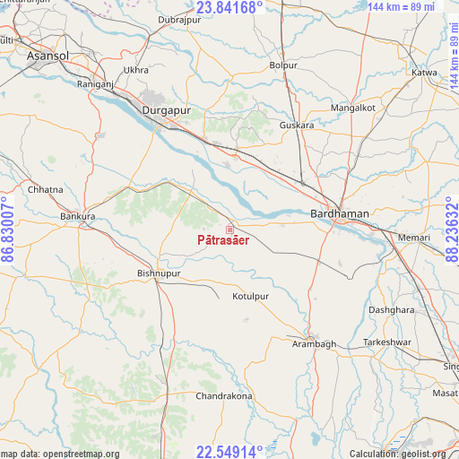
Pātrasāer GPS coordinates[2]
23° 11' 49.092" North, 87° 31' 59.484" East
| Map corner | latitude | longitude |
|---|---|---|
| Upper-left | 23.84168°, | 86.83007° |
| Center: | 23.19697°, | 87.53319° |
| Lower-right: | 22.54914°, | 88.23632° |
| Map W x H: | 143.7×143.7 km | = 89.3×89.3mi |
| max Lat: | 34.9274° ⇑47.1% North |
| Pātrasāer: | 23.19697° |
| min Lat: | ⇓52.9% South 8.09008° |
| min Long | Pātrasāer | max Long |
| 68.82655° | 87.53319° | 96.81° |
| W 90.3%⇐ | ⇒9.7% E |
Elevation
Elevation of Pātrasāer is 58 m = 190 ft, and this is 237.6 m = 780 ft below average elevation for this country.
| Max E: |
3681 m = 12077 ft | 77.2% |
| Avg. | 295.6 m = 970 ft | |
| Pātrasāer | 58 m = 190 ft | |
Min E: |
1 m = 3 ft | 22.8% |
See also: India elevation on elevation.city.
Geographical zone
Pātrasāer is located in North Torrid zone (between Equator and Tropic of Cancer). Distance of this Northern Tropic circle is 26.7 km =16.6 mi to North.| Distance of | km | miles | from Pātrasāer |
|---|---|---|---|
| North Pole | 7427.8 | 4615.4 | to North |
| Arctic Circle | 4821.9 | 2996.2 | to North |
| Tropic Cancer | 26.7 | 16.6 | to North |
| Equator | 2579.3 | 1602.7 | to South |


Nearby cities:
15 places around Pātrasāer: (largest is in red/bold)
• Arāmbāgh
43.3 km =26.9 mi,  143°
143°
• Barddhamān
33.7 km =20.9 mi,  78°
78°
• Barjora
35.7 km =22.2 mi,  315°
315°
• Beliātor
34.7 km =21.6 mi,  293°
293°
• Bishnupur
25.8 km =16 mi,  237°
237°
• Bolpur
54.4 km =33.8 mi,  17°
17°
• Bānkura
47.3 km =29.4 mi,  274°
274°
• Chandrakona
51.6 km =32.1 mi,  181°
181°
• Durgapur
42.3 km =26.3 mi,  327°
327°
• Guskhara
38.8 km =24.1 mi,  32°
32°
• Kharar
54.8 km =34.1 mi,  164°
164°
• Rāmjībanpur
41.7 km =25.9 mi,  169°
169°
• Sonāmukhi
17.2 km =10.7 mi,  314°
314°
• Srirāmpur
56.9 km =35.4 mi,  119°
119°
• Āmlāgora
43.9 km =27.3 mi,  207°
207°
Sources, notices
• [Note1] Compared only with cities in India existing in our database
• [Src1] Map data: © OpenStreetMap contributors (CC-BY-SA)
• [Src2] Other city data from geonames.org with taken over terms of usage.
• [Src3] Geographical zone / Annual Mean Temperature by Robert A. Rohde @ Wikipedia
