Barjora geodata
Barjora (West Bengal) is a populated place; located in India in Asia/Kolkata (GMT+5.5) time zone. With population of 12,294 people, there are 2721 cities with bigger population in this country. Compared to other cities in India, 54.4% of cities are located further ↓South; 89.9% of cities are located further ←West and 72.7% of cities have higher elevation than Barjora. Note1


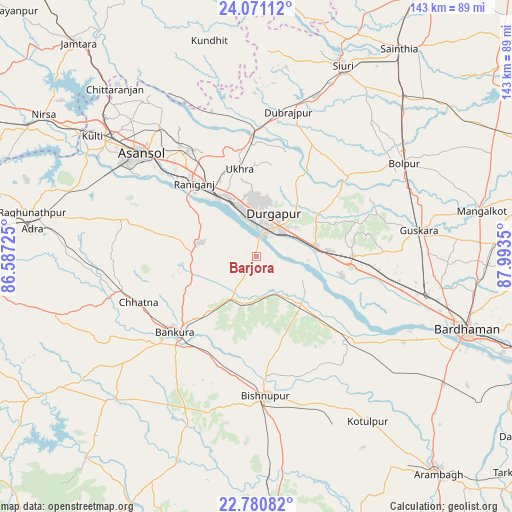
Barjora GPS coordinates[2]
23° 25' 39.144" North, 87° 17' 25.332" East
| Map corner | latitude | longitude |
|---|---|---|
| Upper-left | 24.07112°, | 86.58725° |
| Center: | 23.42754°, | 87.29037° |
| Lower-right: | 22.78082°, | 87.9935° |
| Map W x H: | 143.5×143.5 km | = 89.2×89.2mi |
| max Lat: | 34.9274° ⇑45.6% North |
| Barjora: | 23.42754° |
| min Lat: | ⇓54.4% South 8.09008° |
| min Long | Barjora | max Long |
| 68.82655° | 87.29037° | 96.81° |
| W 89.9%⇐ | ⇒10.1% E |
Elevation
Elevation of Barjora is 81 m = 266 ft, and this is 214.6 m = 704 ft below average elevation for this country.
| Max E: |
3681 m = 12077 ft | 72.7% |
| Avg. | 295.6 m = 970 ft | |
| Barjora | 81 m = 266 ft | |
Min E: |
1 m = 3 ft | 27.3% |
See also: India elevation on elevation.city.
Geographical zone
Barjora is located in North Torrid zone (between Equator and Tropic of Cancer). Distance of this Northern Tropic circle is 1 km =0.6 mi to North.| Distance of | km | miles | from Barjora |
|---|---|---|---|
| North Pole | 7402.2 | 4599.5 | to North |
| Arctic Circle | 4796.3 | 2980.3 | to North |
| Tropic Cancer | 1 | 0.6 | to North |
| Equator | 2604.9 | 1618.6 | to South |


Nearby cities:
15 places around Barjora: (largest is in red/bold)
• Bahula
28 km =17.4 mi,  332°
332°
• Bakreswar
51.4 km =31.9 mi,  9°
9°
• Beliātor
13.9 km =8.6 mi,  210°
210°
• Bishnupur
39.4 km =24.5 mi,  175°
175°
• Bolpur
49 km =30.4 mi,  57°
57°
• Bānkura
31.1 km =19.3 mi,  225°
225°
• Dubrājpur
41.3 km =25.7 mi, 12°
• Durgapur
10 km =6.2 mi, 10°
• Guskhara
45.9 km =28.5 mi,  80°
80°
• Jāmuria
37.6 km =23.4 mi, 325°
• Kulti
56.7 km =35.2 mi,  306°
306°
• Pātrasāer
35.7 km =22.2 mi,  135°
135°
• Rānīganj
26.6 km =16.5 mi,  322°
322°
• Sonāmukhi
18.5 km =11.5 mi, 137°
• Āsansol
42.3 km =26.3 mi, 312°
Sources, notices
• [Note1] Compared only with cities in India existing in our database
• [Src1] Map data: © OpenStreetMap contributors (CC-BY-SA)
• [Src2] Other city data from geonames.org with taken over terms of usage.
• [Src3] Geographical zone / Annual Mean Temperature by Robert A. Rohde @ Wikipedia
