Bar Bigha geodata
Bar Bigha (Bihar) is a populated place; located in India in Asia/Kolkata (GMT+5.5) time zone. With population of 41,758 people, there are 1057 cities with bigger population in this country. Compared to other cities in India, 64.6% of cities are located further ↓South; 86.2% of cities are located further ←West and 78% of cities have higher elevation than Bar Bigha. Note1


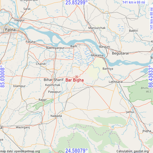
Bar Bigha GPS coordinates[2]
25° 13' 6.78" North, 85° 43' 59.52" East
| Map corner | latitude | longitude |
|---|---|---|
| Upper-left | 25.85299°, | 85.03008° |
| Center: | 25.21855°, | 85.7332° |
| Lower-right: | 24.58079°, | 86.43633° |
| Map W x H: | 141.5×141.5 km | = 87.9×87.9mi |
| max Lat: | 34.9274° ⇑35.4% North |
| Bar Bigha: | 25.21855° |
| min Lat: | ⇓64.6% South 8.09008° |
| min Long | Bar Bigha | max Long |
| 68.82655° | 85.7332° | 96.81° |
| W 86.2%⇐ | ⇒13.8% E |
Elevation
Elevation of Bar Bigha is 55 m = 180 ft, and this is 240.6 m = 789 ft below average elevation for this country.
| Max E: |
3681 m = 12077 ft | 78% |
| Avg. | 295.6 m = 970 ft | |
| Bar Bigha | 55 m = 180 ft | |
Min E: |
1 m = 3 ft | 22% |
See also: Bar Bigha elevation on elevation.city.
Geographical zone
Bar Bigha is located in North temperate zone (between Tropic of Cancer and the Arctic Circle). Distance of this Northern Tropic circle is 198.1 km =123.1 mi to South.| Distance of | km | miles | from Bar Bigha |
|---|---|---|---|
| North Pole | 7203 | 4475.7 | to North |
| Arctic Circle | 4597.1 | 2856.5 | to North |
| Tropic Cancer | 198.1 | 123.1 | to South |
| Equator | 2804 | 1742.3 | to South |


Nearby cities:
15 places around Bar Bigha: (largest is in red/bold)
• Bakhtiyārpur
33.8 km =21 mi,  323°
323°
• Barhiya
29.9 km =18.6 mi,  75°
75°
• Bihār Sharīf
21.1 km =13.1 mi,  264°
264°
• Bārh
29.5 km =18.3 mi,  355°
355°
• Bāruni
37 km =23 mi,  39°
39°
• Khusropur
45.6 km =28.3 mi,  309°
309°
• Luckeesarai
36.7 km =22.8 mi,  97°
97°
• Mohiuddinnagar
40 km =24.9 mi,  350°
350°
• Mokameh
27.4 km =17 mi, 43°
• Nawāda
41.5 km =25.8 mi,  207°
207°
• Rājgīr
37.9 km =23.5 mi,  236°
236°
• Sheikhpura
13.9 km =8.6 mi,  128°
128°
• Silao
34.2 km =21.3 mi, 243°
• Teghra
36.7 km =22.8 mi,  34°
34°
• Wāris Alīganj
24.3 km =15.1 mi,  202°
202°
Sources, notices
• [Note1] Compared only with cities in India existing in our database
• [Src1] Map data: © OpenStreetMap contributors (CC-BY-SA)
• [Src2] Other city data from geonames.org with taken over terms of usage.
• [Src3] Geographical zone / Annual Mean Temperature by Robert A. Rohde @ Wikipedia
