Khusropur geodata
Khusropur (Bihar) is a populated place; located in India in Asia/Kolkata (GMT+5.5) time zone. With population of 12,976 people, there are 2657 cities with bigger population in this country. Compared to other cities in India, 66.8% of cities are located further ↓South; 85.2% of cities are located further ←West and 77.7% of cities have higher elevation than Khusropur. Note1


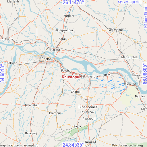
Khusropur GPS coordinates[2]
25° 28' 54.264" North, 85° 23' 5.712" East
| Map corner | latitude | longitude |
|---|---|---|
| Upper-left | 26.11478°, | 84.6818° |
| Center: | 25.48174°, | 85.38492° |
| Lower-right: | 24.84535°, | 86.08805° |
| Map W x H: | 141.1×141.1 km | = 87.7×87.7mi |
| max Lat: | 34.9274° ⇑33.2% North |
| Khusropur: | 25.48174° |
| min Lat: | ⇓66.8% South 8.09008° |
| min Long | Khusropur | max Long |
| 68.82655° | 85.38492° | 96.81° |
| W 85.2%⇐ | ⇒14.8% E |
Elevation
Elevation of Khusropur is 56 m = 184 ft, and this is 239.6 m = 786 ft below average elevation for this country.
| Max E: |
3681 m = 12077 ft | 77.7% |
| Avg. | 295.6 m = 970 ft | |
| Khusropur | 56 m = 184 ft | |
Min E: |
1 m = 3 ft | 22.3% |
See also: India elevation on elevation.city.
Geographical zone
Khusropur is located in North temperate zone (between Tropic of Cancer and the Arctic Circle). Distance of this Northern Tropic circle is 227.4 km =141.3 mi to South.| Distance of | km | miles | from Khusropur |
|---|---|---|---|
| North Pole | 7173.8 | 4457.6 | to North |
| Arctic Circle | 4567.9 | 2838.4 | to North |
| Tropic Cancer | 227.4 | 141.3 | to South |
| Equator | 2833.3 | 1760.5 | to South |


Nearby cities:
15 places around Khusropur: (largest is in red/bold)
• Bakhtiyārpur
14.9 km =9.3 mi,  98°
98°
• Bar Bigha
45.6 km =28.3 mi,  129°
129°
• Bihār Sharīf
34.2 km =21.3 mi,  155°
155°
• Bārh
32.6 km =20.3 mi,  89°
89°
• Dighwāra
47.6 km =29.6 mi,  307°
307°
• Dinapore
38 km =23.6 mi,  297°
297°
• Fatwa
8.6 km =5.3 mi,  291°
291°
• Hilsa
21.1 km =13.1 mi,  209°
209°
• Hājīpur
28.7 km =17.8 mi,  322°
322°
• Islāmpur
42 km =26.1 mi, 205°
• Khagaul
35.7 km =22.2 mi, 287°
• Masaurhi Buzurg
38.2 km =23.7 mi,  248°
248°
• Mohiuddinnagar
30.3 km =18.8 mi,  70°
70°
• Patna
28 km =17.4 mi, 296°
• Silao
44.5 km =27.7 mi,  174°
174°
Sources, notices
• [Note1] Compared only with cities in India existing in our database
• [Src1] Map data: © OpenStreetMap contributors (CC-BY-SA)
• [Src2] Other city data from geonames.org with taken over terms of usage.
• [Src3] Geographical zone / Annual Mean Temperature by Robert A. Rohde @ Wikipedia
