Bakhtiyārpur geodata
Bakhtiyārpur (Bihar) is a populated place; located in India in Asia/Kolkata (GMT+5.5) time zone. With population of 34,533 people, there are 1259 cities with bigger population in this country. Compared to other cities in India, 66.6% of cities are located further ↓South; 85.8% of cities are located further ←West and 78% of cities have higher elevation than Bakhtiyārpur. Note1


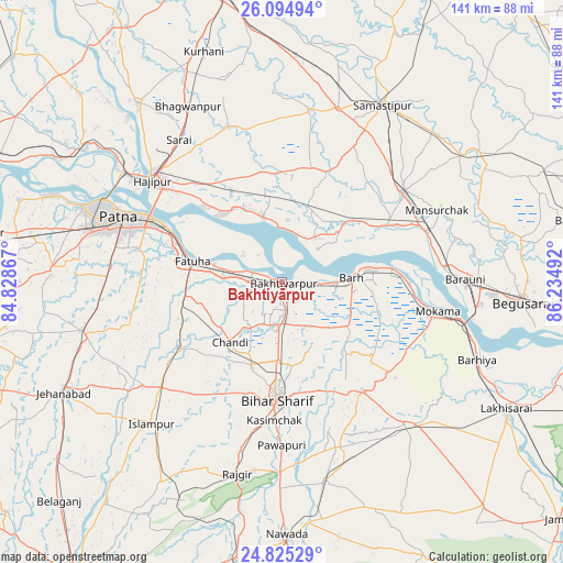
Bakhtiyārpur GPS coordinates[2]
25° 27' 42.444" North, 85° 31' 54.444" East
| Map corner | latitude | longitude |
|---|---|---|
| Upper-left | 26.09494°, | 84.82867° |
| Center: | 25.46179°, | 85.53179° |
| Lower-right: | 24.82529°, | 86.23492° |
| Map W x H: | 141.2×141.2 km | = 87.7×87.7mi |
| max Lat: | 34.9274° ⇑33.4% North |
| Bakhtiyārpur: | 25.46179° |
| min Lat: | ⇓66.6% South 8.09008° |
| min Long | Bakhtiyārpur | max Long |
| 68.82655° | 85.53179° | 96.81° |
| W 85.8%⇐ | ⇒14.2% E |
Elevation
Elevation of Bakhtiyārpur is 55 m = 180 ft, and this is 240.6 m = 789 ft below average elevation for this country.
| Max E: |
3681 m = 12077 ft | 78% |
| Avg. | 295.6 m = 970 ft | |
| Bakhtiyārpur | 55 m = 180 ft | |
Min E: |
1 m = 3 ft | 22% |
See also: India elevation on elevation.city.
Geographical zone
Bakhtiyārpur is located in North temperate zone (between Tropic of Cancer and the Arctic Circle). Distance of this Northern Tropic circle is 225.2 km =139.9 mi to South.| Distance of | km | miles | from Bakhtiyārpur |
|---|---|---|---|
| North Pole | 7176 | 4459 | to North |
| Arctic Circle | 4570.1 | 2839.7 | to North |
| Tropic Cancer | 225.2 | 139.9 | to South |
| Equator | 2831.1 | 1759.2 | to South |


Nearby cities:
15 places around Bakhtiyārpur: (largest is in red/bold)
• Bar Bigha
33.8 km =21 mi,  143°
143°
• Bihār Sharīf
29 km =18 mi,  181°
181°
• Bārh
18 km =11.2 mi,  82°
82°
• Bāruni
43.8 km =27.2 mi,  88°
88°
• Dalsingh Sarai
38.2 km =23.7 mi,  53°
53°
• Fatwa
23.4 km =14.5 mi,  283°
283°
• Hilsa
29.8 km =18.5 mi,  237°
237°
• Hājīpur
40.8 km =25.4 mi,  307°
307°
• Khusropur
14.9 km =9.3 mi, 278°
• Mohiuddinnagar
18.6 km =11.6 mi, 47°
• Mokameh
39.8 km =24.7 mi,  100°
100°
• Patna
42.4 km =26.3 mi,  290°
290°
• Sheikhpura
47.4 km =29.5 mi, 139°
• Silao
43.3 km =26.9 mi,  193°
193°
• Teghra
41.1 km =25.5 mi, 85°
Sources, notices
• [Note1] Compared only with cities in India existing in our database
• [Src1] Map data: © OpenStreetMap contributors (CC-BY-SA)
• [Src2] Other city data from geonames.org with taken over terms of usage.
• [Src3] Geographical zone / Annual Mean Temperature by Robert A. Rohde @ Wikipedia
