Bihār Sharīf geodata
Bihār Sharīf (Bihar) is a populated place; located in India in Asia/Kolkata (GMT+5.5) time zone. With population of 244,230 people, there are 175 cities with bigger population in this country. Compared to other cities in India, 64.5% of cities are located further ↓South; 85.7% of cities are located further ←West and 75% of cities have higher elevation than Bihār Sharīf. Note1


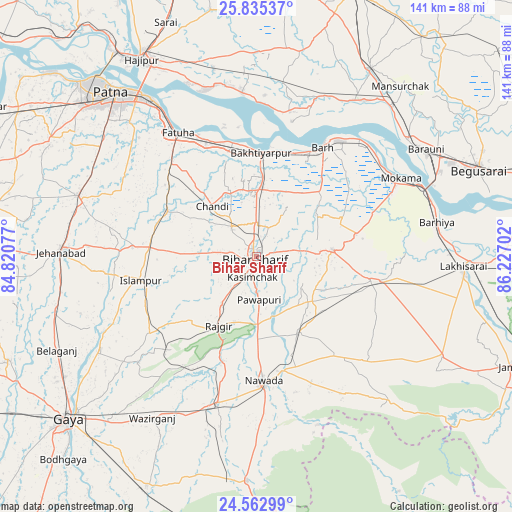
Bihār Sharīf GPS coordinates[2]
25° 12' 3.024" North, 85° 31' 26.004" East
| Map corner | latitude | longitude |
|---|---|---|
| Upper-left | 25.83537°, | 84.82077° |
| Center: | 25.20084°, | 85.52389° |
| Lower-right: | 24.56299°, | 86.22702° |
| Map W x H: | 141.5×141.5 km | = 87.9×87.9mi |
| max Lat: | 34.9274° ⇑35.5% North |
| Bihār Sharīf: | 25.20084° |
| min Lat: | ⇓64.5% South 8.09008° |
| min Long | Bihār Sharīf | max Long |
| 68.82655° | 85.52389° | 96.81° |
| W 85.7%⇐ | ⇒14.3% E |
Elevation
Elevation of Bihār Sharīf is 68 m = 223 ft, and this is 227.6 m = 747 ft below average elevation for this country.
| Max E: |
3681 m = 12077 ft | 75% |
| Avg. | 295.6 m = 970 ft | |
| Bihār Sharīf | 68 m = 223 ft | |
Min E: |
1 m = 3 ft | 25% |
See also: Bihār Sharīf elevation on elevation.city.
Geographical zone
Bihār Sharīf is located in North temperate zone (between Tropic of Cancer and the Arctic Circle). Distance of this Northern Tropic circle is 196.2 km =121.9 mi to South.| Distance of | km | miles | from Bihār Sharīf |
|---|---|---|---|
| North Pole | 7205 | 4477 | to North |
| Arctic Circle | 4599.1 | 2857.7 | to North |
| Tropic Cancer | 196.2 | 121.9 | to South |
| Equator | 2802.1 | 1741.1 | to South |


Nearby cities:
15 places around Bihār Sharīf: (largest is in red/bold)
• Bakhtiyārpur
29 km =18 mi,  1°
1°
• Bar Bigha
21.1 km =13.1 mi,  84°
84°
• Bārh
36.5 km =22.7 mi,  30°
30°
• Fatwa
40.8 km =25.4 mi,  327°
327°
• Hilsa
27.5 km =17.1 mi,  297°
297°
• Hisuā
42.2 km =26.2 mi,  194°
194°
• Islāmpur
32.7 km =20.3 mi,  258°
258°
• Khusropur
34.2 km =21.3 mi,  335°
335°
• Mohiuddinnagar
44 km =27.3 mi,  19°
19°
• Mokameh
45.5 km =28.3 mi,  61°
61°
• Nawāda
35 km =21.7 mi,  176°
176°
• Rājgīr
21.8 km =13.5 mi,  208°
208°
• Sheikhpura
32.6 km =20.3 mi,  101°
101°
• Silao
16.2 km =10.1 mi,  216°
216°
• Wāris Alīganj
23.6 km =14.7 mi,  150°
150°
Sources, notices
• [Note1] Compared only with cities in India existing in our database
• [Src1] Map data: © OpenStreetMap contributors (CC-BY-SA)
• [Src2] Other city data from geonames.org with taken over terms of usage.
• [Src3] Geographical zone / Annual Mean Temperature by Robert A. Rohde @ Wikipedia
