Luckeesarai geodata
Luckeesarai (Bihar) is a populated place; located in India in Asia/Kolkata (GMT+5.5) time zone. With population of 89,500 people, there are 496 cities with bigger population in this country. Compared to other cities in India, 64.3% of cities are located further ↓South; 87.2% of cities are located further ←West and 79.4% of cities have higher elevation than Luckeesarai. Note1


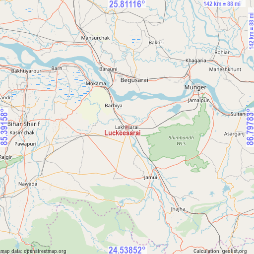
Luckeesarai GPS coordinates[2]
25° 10' 35.4" North, 86° 5' 40.92" East
| Map corner | latitude | longitude |
|---|---|---|
| Upper-left | 25.81116°, | 85.39158° |
| Center: | 25.1765°, | 86.0947° |
| Lower-right: | 24.53852°, | 86.79783° |
| Map W x H: | 141.5×141.5 km | = 87.9×87.9mi |
| max Lat: | 34.9274° ⇑35.7% North |
| Luckeesarai: | 25.1765° |
| min Lat: | ⇓64.3% South 8.09008° |
| min Long | Luckeesarai | max Long |
| 68.82655° | 86.0947° | 96.81° |
| W 87.2%⇐ | ⇒12.8% E |
Elevation
Elevation of Luckeesarai is 50 m = 164 ft, and this is 245.6 m = 806 ft below average elevation for this country.
| Max E: |
3681 m = 12077 ft | 79.4% |
| Avg. | 295.6 m = 970 ft | |
| Luckeesarai | 50 m = 164 ft | |
Min E: |
1 m = 3 ft | 20.6% |
See also: Luckeesarai elevation on elevation.city.
Geographical zone
Luckeesarai is located in North temperate zone (between Tropic of Cancer and the Arctic Circle). Distance of this Northern Tropic circle is 193.4 km =120.2 mi to South.| Distance of | km | miles | from Luckeesarai |
|---|---|---|---|
| North Pole | 7207.7 | 4478.7 | to North |
| Arctic Circle | 4601.8 | 2859.4 | to North |
| Tropic Cancer | 193.4 | 120.2 | to South |
| Equator | 2799.4 | 1739.5 | to South |


Nearby cities:
15 places around Luckeesarai: (largest is in red/bold)
• Bar Bigha
36.7 km =22.8 mi,  277°
277°
• Barhiya
14.5 km =9 mi,  329°
329°
• Bariārpur
50 km =31.1 mi,  75°
75°
• Begusarai
27.2 km =16.9 mi,  8°
8°
• Bārh
51.6 km =32.1 mi,  311°
311°
• Bāruni
35.6 km =22.1 mi,  339°
339°
• Jamālpur
42.4 km =26.3 mi,  69°
69°
• Jamūī
30.8 km =19.1 mi,  154°
154°
• Khagaria
52.1 km =32.4 mi,  45°
45°
• Kharagpur
46.8 km =29.1 mi,  97°
97°
• Mokameh
30 km =18.6 mi,  324°
324°
• Monghyr
44.1 km =27.4 mi,  60°
60°
• Sheikhpura
25.9 km =16.1 mi,  260°
260°
• Teghra
38.2 km =23.7 mi, 335°
• Wāris Alīganj
49 km =30.4 mi,  248°
248°
Sources, notices
• [Note1] Compared only with cities in India existing in our database
• [Src1] Map data: © OpenStreetMap contributors (CC-BY-SA)
• [Src2] Other city data from geonames.org with taken over terms of usage.
• [Src3] Geographical zone / Annual Mean Temperature by Robert A. Rohde @ Wikipedia
