Rabūpura geodata
Rabūpura (Uttar Pradesh) is a populated place; located in India in Asia/Kolkata (GMT+5.5) time zone. With population of 13,949 people, there are 2568 cities with bigger population in this country. Compared to other cities in India, 85.7% of cities are located further ↓South; 56% of cities are located further →East and 50.2% of cities have higher elevation than Rabūpura. Note1


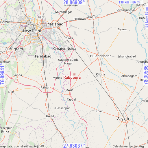
Rabūpura GPS coordinates[2]
28° 15' 5.508" North, 77° 36' 9.108" East
| Map corner | latitude | longitude |
|---|---|---|
| Upper-left | 28.86909°, | 76.89941° |
| Center: | 28.25153°, | 77.60253° |
| Lower-right: | 27.63037°, | 78.30566° |
| Map W x H: | 137.7×137.7 km | = 85.6×85.6mi |
| max Lat: | 34.9274° ⇑14.3% North |
| Rabūpura: | 28.25153° |
| min Lat: | ⇓85.7% South 8.09008° |
| min Long | Rabūpura | max Long |
| 68.82655° | 77.60253° | 96.81° |
| W 44%⇐ | ⇒56% E |
Elevation
Elevation of Rabūpura is 200 m = 656 ft, and this is 95.6 m = 314 ft below average elevation for this country.
| Max E: |
3681 m = 12077 ft | 50.2% |
| Avg. | 295.6 m = 970 ft | |
| Rabūpura | 200 m = 656 ft | |
Min E: |
1 m = 3 ft | 49.8% |
See also: India elevation on elevation.city.
Geographical zone
Rabūpura is located in North temperate zone (between Tropic of Cancer and the Arctic Circle). Distance of this Northern Tropic circle is 535.4 km =332.7 mi to South.| Distance of | km | miles | from Rabūpura |
|---|---|---|---|
| North Pole | 6865.8 | 4266.2 | to North |
| Arctic Circle | 4259.9 | 2647 | to North |
| Tropic Cancer | 535.4 | 332.7 | to South |
| Equator | 3141.3 | 1951.9 | to South |


Nearby cities:
15 places around Rabūpura: (largest is in red/bold)
• Bulandshahr
30.2 km =18.8 mi,  55°
55°
• Bājna
40 km =24.9 mi,  169°
169°
• Bīlāspur
15.7 km =9.8 mi,  7°
7°
• Dankaur
12 km =7.5 mi,  337°
337°
• Dādri
33.8 km =21 mi,  351°
351°
• Faridabad
33.4 km =20.8 mi,  302°
302°
• Greater Noida
28 km =17.4 mi, 346°
• Hasanpur
33.1 km =20.6 mi,  198°
198°
• Jahāngīrpur
12.9 km =8 mi,  128°
128°
• Jewar
15.1 km =9.4 mi, 197°
• Khair
41.7 km =25.9 mi,  145°
145°
• Khurja
24.8 km =15.4 mi,  89°
89°
• Palwal
29.6 km =18.4 mi,  246°
246°
• Shikārpūr
40.4 km =25.1 mi, 85°
• Sikandarābād
24.3 km =15.1 mi,  23°
23°
Sources, notices
• [Note1] Compared only with cities in India existing in our database
• [Src1] Map data: © OpenStreetMap contributors (CC-BY-SA)
• [Src2] Other city data from geonames.org with taken over terms of usage.
• [Src3] Geographical zone / Annual Mean Temperature by Robert A. Rohde @ Wikipedia
