Alīgarh geodata
Alīgarh (Uttar Pradesh) is a populated place; located in India in Asia/Kolkata (GMT+5.5) time zone. With population of 753,207 people, there are 62 cities with bigger population in this country. Compared to other cities in India, 83.8% of cities are located further ↓South; 50.6% of cities are located further →East and 52.2% of cities have higher elevation than Alīgarh. Note1


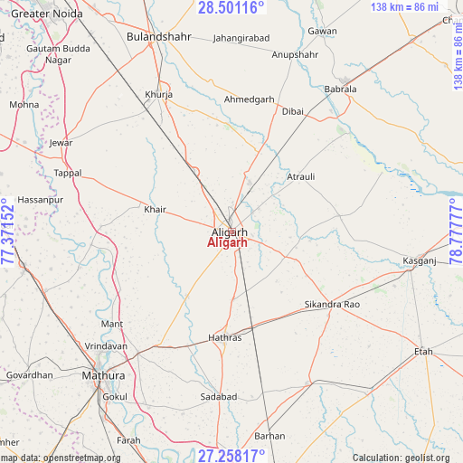
Alīgarh GPS coordinates[2]
27° 52' 53.22" North, 78° 4' 28.704" East
| Map corner | latitude | longitude |
|---|---|---|
| Upper-left | 28.50116°, | 77.37152° |
| Center: | 27.88145°, | 78.07464° |
| Lower-right: | 27.25817°, | 78.77777° |
| Map W x H: | 138.2×138.2 km | = 85.9×85.9mi |
| max Lat: | 34.9274° ⇑16.2% North |
| Alīgarh: | 27.88145° |
| min Lat: | ⇓83.8% South 8.09008° |
| min Long | Alīgarh | max Long |
| 68.82655° | 78.07464° | 96.81° |
| W 49.4%⇐ | ⇒50.6% E |
Elevation
Elevation of Alīgarh is 189 m = 620 ft, and this is 106.6 m = 350 ft below average elevation for this country.
| Max E: |
3681 m = 12077 ft | 52.2% |
| Avg. | 295.6 m = 970 ft | |
| Alīgarh | 189 m = 620 ft | |
Min E: |
1 m = 3 ft | 47.8% |
See also: Alīgarh elevation on elevation.city.
Geographical zone
Alīgarh is located in North temperate zone (between Tropic of Cancer and the Arctic Circle). Distance of this Northern Tropic circle is 494.2 km =307.1 mi to South.| Distance of | km | miles | from Alīgarh |
|---|---|---|---|
| North Pole | 6906.9 | 4291.7 | to North |
| Arctic Circle | 4301 | 2672.5 | to North |
| Tropic Cancer | 494.2 | 307.1 | to South |
| Equator | 3100.1 | 1926.3 | to South |


Nearby cities:
15 places around Alīgarh: (largest is in red/bold)
• Atraulī
26.5 km =16.5 mi,  51°
51°
• Beswān
33.2 km =20.6 mi,  215°
215°
• Bājna
39 km =24.2 mi,  272°
272°
• Chharra
32.4 km =20.1 mi,  81°
81°
• Dibai
40.7 km =25.3 mi,  26°
26°
• Harduāganj
10.7 km =6.6 mi, 49°
• Hāthras
31.9 km =19.8 mi,  184°
184°
• Iglās
23.1 km =14.4 mi, 215°
• Jalālī
17.6 km =10.9 mi,  95°
95°
• Khair
23.8 km =14.8 mi,  286°
286°
• Mursān
36.2 km =22.5 mi,  201°
201°
• Pahāsu
32.3 km =20.1 mi,  358°
358°
• Shikārpūr
44.8 km =27.8 mi,  352°
352°
• Sikandra Rao
36.9 km =22.9 mi,  125°
125°
• Sāsni
19.9 km =12.4 mi, 177°
Sources, notices
• [Note1] Compared only with cities in India existing in our database
• [Src1] Map data: © OpenStreetMap contributors (CC-BY-SA)
• [Src2] Other city data from geonames.org with taken over terms of usage.
• [Src3] Geographical zone / Annual Mean Temperature by Robert A. Rohde @ Wikipedia
