Jahāngīrpur geodata
Jahāngīrpur (Uttar Pradesh) is a populated place; located in India in Asia/Kolkata (GMT+5.5) time zone. With population of 10,042 people, there are 2936 cities with bigger population in this country. Compared to other cities in India, 85.2% of cities are located further ↓South; 54.9% of cities are located further →East and 50.5% of cities have higher elevation than Jahāngīrpur. Note1


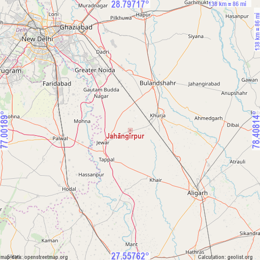
Jahāngīrpur GPS coordinates[2]
28° 10' 45.084" North, 77° 42' 18.036" East
| Map corner | latitude | longitude |
|---|---|---|
| Upper-left | 28.79717°, | 77.00189° |
| Center: | 28.17919°, | 77.70501° |
| Lower-right: | 27.55762°, | 78.40814° |
| Map W x H: | 137.8×137.8 km | = 85.6×85.6mi |
| max Lat: | 34.9274° ⇑14.8% North |
| Jahāngīrpur: | 28.17919° |
| min Lat: | ⇓85.2% South 8.09008° |
| min Long | Jahāngīrpur | max Long |
| 68.82655° | 77.70501° | 96.81° |
| W 45.1%⇐ | ⇒54.9% E |
Elevation
Elevation of Jahāngīrpur is 199 m = 653 ft, and this is 96.6 m = 317 ft below average elevation for this country.
| Max E: |
3681 m = 12077 ft | 50.5% |
| Avg. | 295.6 m = 970 ft | |
| Jahāngīrpur | 199 m = 653 ft | |
Min E: |
1 m = 3 ft | 49.5% |
See also: India elevation on elevation.city.
Geographical zone
Jahāngīrpur is located in North temperate zone (between Tropic of Cancer and the Arctic Circle). Distance of this Northern Tropic circle is 527.3 km =327.6 mi to South.| Distance of | km | miles | from Jahāngīrpur |
|---|---|---|---|
| North Pole | 6873.8 | 4271.2 | to North |
| Arctic Circle | 4267.9 | 2651.9 | to North |
| Tropic Cancer | 527.3 | 327.6 | to South |
| Equator | 3133.2 | 1946.9 | to South |


Nearby cities:
15 places around Jahāngīrpur: (largest is in red/bold)
• Bulandshahr
29.1 km =18.1 mi,  30°
30°
• Bājna
31.4 km =19.5 mi,  184°
184°
• Bīlāspur
24.9 km =15.5 mi,  341°
341°
• Dankaur
24.1 km =15 mi,  322°
322°
• Dādri
44.1 km =27.4 mi, 340°
• Greater Noida
38.9 km =24.2 mi,  334°
334°
• Hasanpur
31.1 km =19.3 mi,  221°
221°
• Jewar
15.8 km =9.8 mi,  246°
246°
• Khair
29.6 km =18.4 mi,  152°
152°
• Khurja
16.9 km =10.5 mi,  60°
60°
• Pahāsu
35.2 km =21.9 mi,  91°
91°
• Palwal
37.4 km =23.2 mi,  264°
264°
• Rabūpura
12.9 km =8 mi,  308°
308°
• Shikārpūr
32.3 km =20.1 mi,  69°
69°
• Sikandarābād
30.4 km =18.9 mi,  359°
359°
Sources, notices
• [Note1] Compared only with cities in India existing in our database
• [Src1] Map data: © OpenStreetMap contributors (CC-BY-SA)
• [Src2] Other city data from geonames.org with taken over terms of usage.
• [Src3] Geographical zone / Annual Mean Temperature by Robert A. Rohde @ Wikipedia
