Azhikkal geodata
Azhikkal (Kerala) is a populated place; located in India in Asia/Kolkata (GMT+5.5) time zone. With population of 8,117 people, there are 3117 cities with bigger population in this country. Compared to other cities in India, 90.1% of cities are located further ↑North; 79.7% of cities are located further →East and 85.8% of cities have higher elevation than Azhikkal. Note1


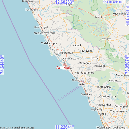
Azhikkal GPS coordinates[2]
11° 54' 54.864" North, 75° 20' 51.396" East
| Map corner | latitude | longitude |
|---|---|---|
| Upper-left | 12.60233°, | 74.64449° |
| Center: | 11.91524°, | 75.34761° |
| Lower-right: | 11.22641°, | 76.05074° |
| Map W x H: | 153×153 km | = 95.1×95.1mi |
| max Lat: | 34.9274° ⇑90.1% North |
| Azhikkal: | 11.91524° |
| min Lat: | ⇓9.9% South 8.09008° |
| min Long | Azhikkal | max Long |
| 68.82655° | 75.34761° | 96.81° |
| W 20.3%⇐ | ⇒79.7% E |
Elevation
Elevation of Azhikkal is 28 m = 92 ft, and this is 267.6 m = 878 ft below average elevation for this country.
| Max E: |
3681 m = 12077 ft | 85.8% |
| Avg. | 295.6 m = 970 ft | |
| Azhikkal | 28 m = 92 ft | |
Min E: |
1 m = 3 ft | 14.2% |
See also: India elevation on elevation.city.
Geographical zone
Azhikkal is located in North Torrid zone (between Equator and Tropic of Cancer). Distance of this Northern Tropic circle is 1281.1 km =796 mi to North.| Distance of | km | miles | from Azhikkal |
|---|---|---|---|
| North Pole | 8682.2 | 5394.9 | to North |
| Arctic Circle | 6076.3 | 3775.6 | to North |
| Tropic Cancer | 1281.1 | 796 | to North |
| Equator | 1324.9 | 823.3 | to South |


Nearby cities:
15 places around Azhikkal: (largest is in red/bold)
• Badagara
43.5 km =27 mi,  144°
144°
• Dharmadam
20.1 km =12.5 mi, 140°
• Iringal
49.2 km =30.6 mi, 143°
• Kannavam
35.2 km =21.9 mi,  102°
102°
• Kannur
5.4 km =3.4 mi,  168°
168°
• Kānnangād
51 km =31.7 mi,  329°
329°
• Mahē
31.3 km =19.4 mi, 139°
• Mattanur
24.4 km =15.2 mi,  86°
86°
• Muluppilagadu
17.2 km =10.7 mi, 139°
• Nādāpuram
42.1 km =26.2 mi,  127°
127°
• Nīlēshwar
44.7 km =27.8 mi, 328°
• Payyannūr
25.3 km =15.7 mi,  321°
321°
• Pāppinisshēri
4.7 km =2.9 mi,  350°
350°
• Talipparamba
14.1 km =8.8 mi,  5°
5°
• Tellicherry
24.4 km =15.2 mi, 139°
Sources, notices
• [Note1] Compared only with cities in India existing in our database
• [Src1] Map data: © OpenStreetMap contributors (CC-BY-SA)
• [Src2] Other city data from geonames.org with taken over terms of usage.
• [Src3] Geographical zone / Annual Mean Temperature by Robert A. Rohde @ Wikipedia
