Bhanjanagar geodata
Bhanjanagar (Odisha) is a populated place; located in India in Asia/Kolkata (GMT+5.5) time zone. With population of 20,647 people, there are 1993 cities with bigger population in this country. Compared to other cities in India, 65.5% of cities are located further ↑North; 83.2% of cities are located further ←West and 71.5% of cities have higher elevation than Bhanjanagar. Note1


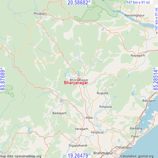
Bhanjanagar GPS coordinates[2]
19° 55' 37.884" North, 84° 34' 55.236" East
| Map corner | latitude | longitude |
|---|---|---|
| Upper-left | 20.58682°, | 83.87889° |
| Center: | 19.92719°, | 84.58201° |
| Lower-right: | 19.26479°, | 85.28514° |
| Map W x H: | 147×147 km | = 91.3×91.3mi |
| max Lat: | 34.9274° ⇑65.5% North |
| Bhanjanagar: | 19.92719° |
| min Lat: | ⇓34.5% South 8.09008° |
| min Long | Bhanjanagar | max Long |
| 68.82655° | 84.58201° | 96.81° |
| W 83.2%⇐ | ⇒16.8% E |
Elevation
Elevation of Bhanjanagar is 86 m = 282 ft, and this is 209.6 m = 688 ft below average elevation for this country.
| Max E: |
3681 m = 12077 ft | 71.5% |
| Avg. | 295.6 m = 970 ft | |
| Bhanjanagar | 86 m = 282 ft | |
Min E: |
1 m = 3 ft | 28.5% |
See also: India elevation on elevation.city.
Geographical zone
Bhanjanagar is located in North Torrid zone (between Equator and Tropic of Cancer). Distance of this Northern Tropic circle is 390.2 km =242.5 mi to North.| Distance of | km | miles | from Bhanjanagar |
|---|---|---|---|
| North Pole | 7791.4 | 4841.4 | to North |
| Arctic Circle | 5185.5 | 3222.1 | to North |
| Tropic Cancer | 390.2 | 242.5 | to North |
| Equator | 2215.7 | 1376.8 | to South |


Nearby cities:
15 places around Bhanjanagar: (largest is in red/bold)
• Belaguntha
7.7 km =4.8 mi,  130°
130°
• Buguda
25.5 km =15.8 mi,  121°
121°
• Bālugaon
62.1 km =38.6 mi,  63°
63°
• Bānapur
63.7 km =39.6 mi,  105°
105°
• Digapahandi
61.7 km =38.3 mi,  180°
180°
• Hinjilikatu
52.4 km =32.6 mi,  161°
161°
• Khallikot
63.5 km =39.5 mi, 123°
• Kodala
50.4 km =31.3 mi, 131°
• Nayāgarh
58.2 km =36.2 mi,  67°
67°
• Polasara
35.5 km =22.1 mi,  136°
136°
• Purushottampur
55.3 km =34.4 mi, 144°
• Rambha
70.9 km =44.1 mi, 130°
• Sorada
24.4 km =15.2 mi,  220°
220°
• Udayagiri
31.2 km =19.4 mi,  314°
314°
• Āsika
36.1 km =22.4 mi,  166°
166°
Sources, notices
• [Note1] Compared only with cities in India existing in our database
• [Src1] Map data: © OpenStreetMap contributors (CC-BY-SA)
• [Src2] Other city data from geonames.org with taken over terms of usage.
• [Src3] Geographical zone / Annual Mean Temperature by Robert A. Rohde @ Wikipedia
