Belaguntha geodata
Belaguntha (Odisha) is a populated place; located in India in Asia/Kolkata (GMT+5.5) time zone. With population of 10,360 people, there are 2906 cities with bigger population in this country. Compared to other cities in India, 65.6% of cities are located further ↑North; 83.4% of cities are located further ←West and 73.3% of cities have higher elevation than Belaguntha. Note1


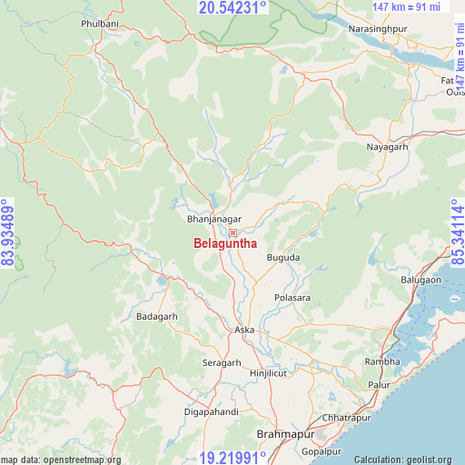
Belaguntha GPS coordinates[2]
19° 52' 56.964" North, 84° 38' 16.836" East
| Map corner | latitude | longitude |
|---|---|---|
| Upper-left | 20.54231°, | 83.93489° |
| Center: | 19.88249°, | 84.63801° |
| Lower-right: | 19.21991°, | 85.34114° |
| Map W x H: | 147×147 km | = 91.3×91.3mi |
| max Lat: | 34.9274° ⇑65.6% North |
| Belaguntha: | 19.88249° |
| min Lat: | ⇓34.4% South 8.09008° |
| min Long | Belaguntha | max Long |
| 68.82655° | 84.63801° | 96.81° |
| W 83.4%⇐ | ⇒16.6% E |
Elevation
Elevation of Belaguntha is 78 m = 256 ft, and this is 217.6 m = 714 ft below average elevation for this country.
| Max E: |
3681 m = 12077 ft | 73.3% |
| Avg. | 295.6 m = 970 ft | |
| Belaguntha | 78 m = 256 ft | |
Min E: |
1 m = 3 ft | 26.7% |
See also: India elevation on elevation.city.
Geographical zone
Belaguntha is located in North Torrid zone (between Equator and Tropic of Cancer). Distance of this Northern Tropic circle is 395.2 km =245.6 mi to North.| Distance of | km | miles | from Belaguntha |
|---|---|---|---|
| North Pole | 7796.3 | 4844.4 | to North |
| Arctic Circle | 5190.4 | 3225.2 | to North |
| Tropic Cancer | 395.2 | 245.6 | to North |
| Equator | 2210.7 | 1373.7 | to South |


Nearby cities:
15 places around Belaguntha: (largest is in red/bold)
• Bhanjanagar
7.7 km =4.8 mi,  310°
310°
• Buguda
18 km =11.2 mi,  117°
117°
• Bālugaon
59.6 km =37 mi,  56°
56°
• Bānapur
56.9 km =35.4 mi,  101°
101°
• Digapahandi
57.1 km =35.5 mi,  186°
186°
• Hinjilikatu
46 km =28.6 mi,  165°
165°
• Khallikot
55.9 km =34.7 mi, 122°
• Kodala
42.8 km =26.6 mi,  132°
132°
• Nayāgarh
55.2 km =34.3 mi, 60°
• Polasara
27.9 km =17.3 mi,  138°
138°
• Purushottampur
47.9 km =29.8 mi,  147°
147°
• Rambha
63.2 km =39.3 mi, 130°
• Sorada
25.6 km =15.9 mi,  238°
238°
• Udayagiri
38.9 km =24.2 mi, 313°
• Āsika
30.3 km =18.8 mi,  175°
175°
Sources, notices
• [Note1] Compared only with cities in India existing in our database
• [Src1] Map data: © OpenStreetMap contributors (CC-BY-SA)
• [Src2] Other city data from geonames.org with taken over terms of usage.
• [Src3] Geographical zone / Annual Mean Temperature by Robert A. Rohde @ Wikipedia
