Amarpātan geodata
Amarpātan (Madhya Pradesh) is a populated place; located in India in Asia/Kolkata (GMT+5.5) time zone. With population of 16,858 people, there are 2297 cities with bigger population in this country. Compared to other cities in India, 59.7% of cities are located further ↓South; 72.8% of cities are located further ←West and 73.1% of cities have lower elevation than Amarpātan. Note1


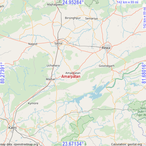
Amarpātan GPS coordinates[2]
24° 18' 49.356" North, 80° 58' 37.308" East
| Map corner | latitude | longitude |
|---|---|---|
| Upper-left | 24.95284°, | 80.27391° |
| Center: | 24.31371°, | 80.97703° |
| Lower-right: | 23.67134°, | 81.68016° |
| Map W x H: | 142.5×142.5 km | = 88.5×88.5mi |
| max Lat: | 34.9274° ⇑40.3% North |
| Amarpātan: | 24.31371° |
| min Lat: | ⇓59.7% South 8.09008° |
| min Long | Amarpātan | max Long |
| 68.82655° | 80.97703° | 96.81° |
| W 72.8%⇐ | ⇒27.2% E |
Elevation
Elevation of Amarpātan is 362 m = 1188 ft, and this is 66.4 m = 218 ft above average elevation for this country.
| Max E: |
3681 m = 12077 ft | 26.9% |
| Amarpātan | 362 m 1188 ft | |
| Avg. | 295.6 m = 970 ft | |
Min E: |
1 m = 3 ft | 73.1% |
See also: India elevation on elevation.city.
Geographical zone
Amarpātan is located in North temperate zone (between Tropic of Cancer and the Arctic Circle). Distance of this Northern Tropic circle is 97.5 km =60.6 mi to South.| Distance of | km | miles | from Amarpātan |
|---|---|---|---|
| North Pole | 7303.6 | 4538.2 | to North |
| Arctic Circle | 4697.7 | 2919 | to North |
| Tropic Cancer | 97.5 | 60.6 | to South |
| Equator | 2703.4 | 1679.8 | to South |


Nearby cities:
15 places around Amarpātan: (largest is in red/bold)
• Baikunthpur
63.5 km =39.5 mi,  43°
43°
• Barhi
48.5 km =30.1 mi,  199°
199°
• Beohāri
51.9 km =32.2 mi,  128°
128°
• Govindgarh
33.1 km =20.6 mi,  77°
77°
• Gurh
57 km =35.4 mi,  68°
68°
• Kothi
52.8 km =32.8 mi,  337°
337°
• Kotār
42.7 km =26.5 mi,  0°
0°
• Madhogarh
28.6 km =17.8 mi,  346°
346°
• Maihar
22.6 km =14 mi,  256°
256°
• Mangawān
69.8 km =43.4 mi,  55°
55°
• Nāgod
48.6 km =30.2 mi,  305°
305°
• Rewa
40.1 km =24.9 mi,  52°
52°
• Satna
33 km =20.5 mi,  332°
332°
• Simaria
56.4 km =35 mi,  18°
18°
• Sirmaur
70.1 km =43.6 mi,  33°
33°
Sources, notices
• [Note1] Compared only with cities in India existing in our database
• [Src1] Map data: © OpenStreetMap contributors (CC-BY-SA)
• [Src2] Other city data from geonames.org with taken over terms of usage.
• [Src3] Geographical zone / Annual Mean Temperature by Robert A. Rohde @ Wikipedia
