Maihar geodata
Maihar (Madhya Pradesh) is a populated place; located in India in Asia/Kolkata (GMT+5.5) time zone. With population of 37,913 people, there are 1160 cities with bigger population in this country. Compared to other cities in India, 59.3% of cities are located further ↓South; 72% of cities are located further ←West and 72.7% of cities have lower elevation than Maihar. Note1


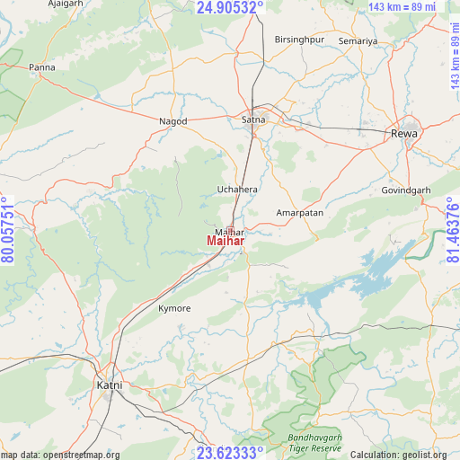
Maihar GPS coordinates[2]
24° 15' 57.384" North, 80° 45' 38.268" East
| Map corner | latitude | longitude |
|---|---|---|
| Upper-left | 24.90532°, | 80.05751° |
| Center: | 24.26594°, | 80.76063° |
| Lower-right: | 23.62333°, | 81.46376° |
| Map W x H: | 142.5×142.5 km | = 88.5×88.5mi |
| max Lat: | 34.9274° ⇑40.7% North |
| Maihar: | 24.26594° |
| min Lat: | ⇓59.3% South 8.09008° |
| min Long | Maihar | max Long |
| 68.82655° | 80.76063° | 96.81° |
| W 72%⇐ | ⇒28% E |
Elevation
Elevation of Maihar is 358 m = 1175 ft, and this is 62.4 m = 205 ft above average elevation for this country.
| Max E: |
3681 m = 12077 ft | 27.3% |
| Maihar | 358 m 1175 ft | |
| Avg. | 295.6 m = 970 ft | |
Min E: |
1 m = 3 ft | 72.7% |
See also: India elevation on elevation.city.
Geographical zone
Maihar is located in North temperate zone (between Tropic of Cancer and the Arctic Circle). Distance of this Northern Tropic circle is 92.2 km =57.3 mi to South.| Distance of | km | miles | from Maihar |
|---|---|---|---|
| North Pole | 7308.9 | 4541.5 | to North |
| Arctic Circle | 4703.1 | 2922.4 | to North |
| Tropic Cancer | 92.2 | 57.3 | to South |
| Equator | 2698.1 | 1676.5 | to South |


Nearby cities:
15 places around Maihar: (largest is in red/bold)
• Amarpātan
22.6 km =14 mi,  76°
76°
• Amānganj
75.6 km =47 mi,  283°
283°
• Barhi
40.7 km =25.3 mi,  172°
172°
• Beohāri
68.2 km =42.4 mi,  113°
113°
• Chandia
68 km =42.3 mi,  184°
184°
• Govindgarh
55.7 km =34.6 mi, 77°
• Kothi
54.1 km =33.6 mi,  1°
1°
• Kotār
53 km =32.9 mi,  24°
24°
• Madhogarh
36.5 km =22.7 mi, 24°
• Murwāra
60.4 km =37.5 mi,  218°
218°
• Nāgod
38 km =23.6 mi,  332°
332°
• Pawai
60.7 km =37.7 mi,  270°
270°
• Rewa
61.5 km =38.2 mi,  61°
61°
• Satna
35.3 km =21.9 mi,  11°
11°
• Simaria
70.9 km =44.1 mi,  33°
33°
Sources, notices
• [Note1] Compared only with cities in India existing in our database
• [Src1] Map data: © OpenStreetMap contributors (CC-BY-SA)
• [Src2] Other city data from geonames.org with taken over terms of usage.
• [Src3] Geographical zone / Annual Mean Temperature by Robert A. Rohde @ Wikipedia
