Beohāri geodata
Beohāri (Madhya Pradesh) is a populated place; located in India in Asia/Kolkata (GMT+5.5) time zone. With population of 22,107 people, there are 1899 cities with bigger population in this country. Compared to other cities in India, 58.2% of cities are located further ↓South; 74.2% of cities are located further ←West and 75.1% of cities have lower elevation than Beohāri. Note1


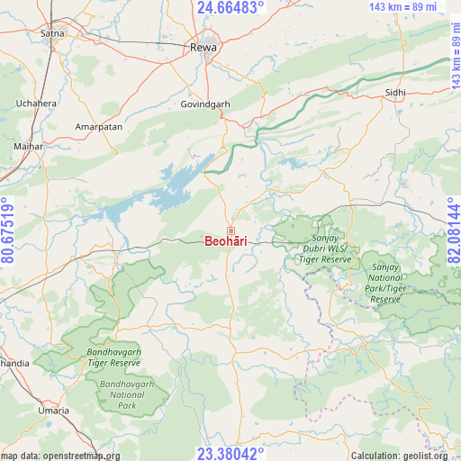
Beohāri GPS coordinates[2]
24° 1' 27.228" North, 81° 22' 41.916" East
| Map corner | latitude | longitude |
|---|---|---|
| Upper-left | 24.66483°, | 80.67519° |
| Center: | 24.02423°, | 81.37831° |
| Lower-right: | 23.38042°, | 82.08144° |
| Map W x H: | 142.8×142.8 km | = 88.7×88.7mi |
| max Lat: | 34.9274° ⇑41.8% North |
| Beohāri: | 24.02423° |
| min Lat: | ⇓58.2% South 8.09008° |
| min Long | Beohāri | max Long |
| 68.82655° | 81.37831° | 96.81° |
| W 74.2%⇐ | ⇒25.8% E |
Elevation
Elevation of Beohāri is 388 m = 1273 ft, and this is 92.4 m = 303 ft above average elevation for this country.
| Max E: |
3681 m = 12077 ft | 24.9% |
| Beohāri | 388 m 1273 ft | |
| Avg. | 295.6 m = 970 ft | |
Min E: |
1 m = 3 ft | 75.1% |
See also: India elevation on elevation.city.
Geographical zone
Beohāri is located in North temperate zone (between Tropic of Cancer and the Arctic Circle). Distance of this Northern Tropic circle is 65.3 km =40.6 mi to South.| Distance of | km | miles | from Beohāri |
|---|---|---|---|
| North Pole | 7335.8 | 4558.3 | to North |
| Arctic Circle | 4729.9 | 2939 | to North |
| Tropic Cancer | 65.3 | 40.6 | to South |
| Equator | 2671.2 | 1659.8 | to South |


Nearby cities:
15 places around Beohāri: (largest is in red/bold)
• Amarpātan
51.9 km =32.2 mi,  308°
308°
• Baikunthpur
78.3 km =48.7 mi,  2°
2°
• Barhi
58.8 km =36.5 mi,  256°
256°
• Chandia
79.4 km =49.3 mi,  239°
239°
• Chorhat
53.7 km =33.4 mi,  33°
33°
• Govindgarh
40.3 km =25 mi,  348°
348°
• Gurh
54.6 km =33.9 mi,  13°
13°
• Jaisinghnagar
37.6 km =23.4 mi,  178°
178°
• Madhogarh
76.4 km =47.5 mi,  321°
321°
• Maihar
68.2 km =42.4 mi,  293°
293°
• Mangawān
73.5 km =45.7 mi, 13°
• Pāli
80.9 km =50.3 mi,  204°
204°
• Rewa
57.2 km =35.5 mi, 351°
• Sidhi
66.1 km =41.1 mi,  50°
50°
• Umaria
78.2 km =48.6 mi,  224°
224°
Sources, notices
• [Note1] Compared only with cities in India existing in our database
• [Src1] Map data: © OpenStreetMap contributors (CC-BY-SA)
• [Src2] Other city data from geonames.org with taken over terms of usage.
• [Src3] Geographical zone / Annual Mean Temperature by Robert A. Rohde @ Wikipedia
