Kothi geodata
Kothi (Madhya Pradesh) is a populated place; located in India in Asia/Kolkata (GMT+5.5) time zone. With population of 7,790 people, there are 3140 cities with bigger population in this country. Compared to other cities in India, 62.1% of cities are located further ↓South; 72.1% of cities are located further ←West and 70% of cities have lower elevation than Kothi. Note1


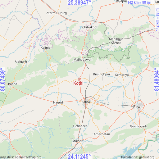
Kothi GPS coordinates[2]
24° 45' 9.36" North, 80° 46' 39.036" East
| Map corner | latitude | longitude |
|---|---|---|
| Upper-left | 25.38947°, | 80.07439° |
| Center: | 24.7526°, | 80.77751° |
| Lower-right: | 24.11245°, | 81.48064° |
| Map W x H: | 142×142 km | = 88.2×88.2mi |
| max Lat: | 34.9274° ⇑37.9% North |
| Kothi: | 24.7526° |
| min Lat: | ⇓62.1% South 8.09008° |
| min Long | Kothi | max Long |
| 68.82655° | 80.77751° | 96.81° |
| W 72.1%⇐ | ⇒27.9% E |
Elevation
Elevation of Kothi is 327 m = 1073 ft, and this is 31.4 m = 103 ft above average elevation for this country.
| Max E: |
3681 m = 12077 ft | 30% |
| Kothi | 327 m 1073 ft | |
| Avg. | 295.6 m = 970 ft | |
Min E: |
1 m = 3 ft | 70% |
See also: India elevation on elevation.city.
Geographical zone
Kothi is located in North temperate zone (between Tropic of Cancer and the Arctic Circle). Distance of this Northern Tropic circle is 146.3 km =90.9 mi to South.| Distance of | km | miles | from Kothi |
|---|---|---|---|
| North Pole | 7254.8 | 4507.9 | to North |
| Arctic Circle | 4648.9 | 2888.7 | to North |
| Tropic Cancer | 146.3 | 90.9 | to South |
| Equator | 2752.2 | 1710.1 | to South |


Nearby cities:
15 places around Kothi: (largest is in red/bold)
• Ajaigarh
54.8 km =34.1 mi,  287°
287°
• Amarpātan
52.8 km =32.8 mi,  157°
157°
• Atarra
62.9 km =39.1 mi,  340°
340°
• Kotwa
62.8 km =39 mi,  60°
60°
• Kotār
21.4 km =13.3 mi,  106°
106°
• Madhogarh
24.9 km =15.5 mi,  147°
147°
• Maihar
54.1 km =33.6 mi,  181°
181°
• Mānikpur
47.2 km =29.3 mi,  43°
43°
• Naraini
57.4 km =35.7 mi,  327°
327°
• Nāgod
28 km =17.4 mi,  223°
223°
• Panna
59.7 km =37.1 mi,  266°
266°
• Rewa
57.5 km =35.7 mi,  115°
115°
• Satna
20.1 km =12.5 mi,  165°
165°
• Simaria
38.1 km =23.7 mi,  82°
82°
• Sirmaur
60 km =37.3 mi, 81°
Sources, notices
• [Note1] Compared only with cities in India existing in our database
• [Src1] Map data: © OpenStreetMap contributors (CC-BY-SA)
• [Src2] Other city data from geonames.org with taken over terms of usage.
• [Src3] Geographical zone / Annual Mean Temperature by Robert A. Rohde @ Wikipedia
