Nāḩīyat Saddat al Hindīyah geodata
Nāḩīyat Saddat al Hindīyah (Bābil) is a populated place; located in Iraq in Asia/Baghdad (GMT+3) time zone. With population of 30,622 people, there are 53 cities with bigger population in this country. Compared to other cities in Iraq, 67.6% of cities are located further ↑North; 59.9% of cities are located further →East and 68.3% of cities have higher elevation than Nāḩīyat Saddat al Hindīyah. Note1
Current local time in Nāḩīyat Saddat al Hindīyah:
09:23 AM, WednesdayDifference from your time zone: hours


Nāḩīyat Saddat al Hindīyah GPS coordinates[2]
32° 42' 56.052" North, 44° 16' 42.852" East
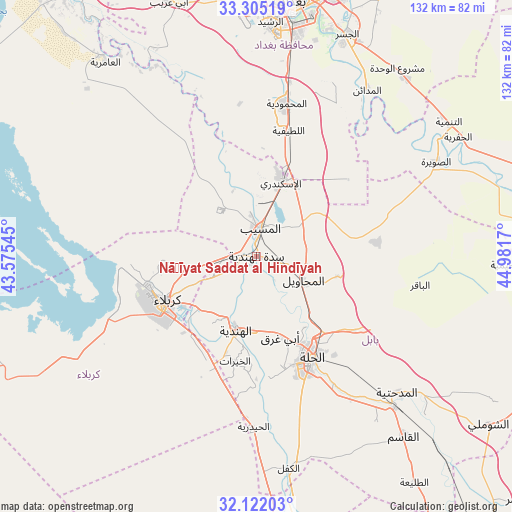
| Map corner | latitude | longitude |
|---|---|---|
| Upper-left | 33.30519°, | 43.57545° |
| Center: | 32.71557°, | 44.27857° |
| Lower-right: | 32.12203°, | 44.9817° |
| Map W x H: | 131.6×131.6 km | = 81.8×81.8mi |
| max Lat: | 37.22781° ⇑67.6% North |
| Nāḩīyat Saddat al Hindīyah: | 32.71557° |
| min Lat: | ⇓32.4% South 29.97421° |
| min Long | Nāḩīyat Sad | max Long |
| 40.28586° | 44.27857° | 48.47309° |
| W 40.1%⇐ | ⇒59.9% E |
Elevation
Elevation of Nāḩīyat Saddat al Hindīyah is 36 m = 118 ft, and this is 257 m = 843 ft below average elevation for this country.
| Max E: |
1316 m = 4318 ft | 68.3% |
| Avg. | 293 m = 961 ft | |
| Nāḩīyat Saddat al Hindīyah | 36 m = 118 ft | |
Min E: |
1 m = 3 ft | 31.7% |
See also: Iraq elevation on elevation.city.
Geographical zone
Nāḩīyat Saddat al Hindīyah is located in North temperate zone (between Tropic of Cancer and the Arctic Circle). Distance of this Northern Tropic circle is 1031.7 km =641.1 mi to South.| Distance of | km | miles | from Nāḩīyat Saddat al Hindīyah |
|---|---|---|---|
| North Pole | 6369.4 | 3957.8 | to North |
| Arctic Circle | 3763.5 | 2338.5 | to North |
| Tropic Cancer | 1031.7 | 641.1 | to South |
| Equator | 3637.6 | 2260.3 | to South |


Nearby cities:
15 places around Nāḩīyat Saddat al Hindīyah: (largest is in red/bold)
• Abū Ghurayb
66.2 km =41.1 mi,  352°
352°
• Al Hindīyah
19.4 km =12.1 mi,  194°
194°
• Al Hāshimīyah
53 km =32.9 mi,  137°
137°
• Al Maḩmūdīyah
39.4 km =24.5 mi,  11°
11°
• Al Maḩāwīl
13.6 km =8.5 mi,  116°
116°
• Al Musayyib
7.1 km =4.4 mi, 8°
• Al Ḩillah
31 km =19.3 mi,  154°
154°
• Al ‘Azīzīyah
76.5 km =47.5 mi,  73°
73°
• Aş Şuwayrah
52 km =32.3 mi,  63°
63°
• Baghdad
70.4 km =43.7 mi, 9°
• Imam Qasim
59.9 km =37.2 mi, 140°
• Karbala
26.2 km =16.3 mi,  245°
245°
• Kufa
75.4 km =46.9 mi,  168°
168°
• Najaf
76.9 km =47.8 mi,  175°
175°
• ‘Ayn Tamr
75.8 km =47.1 mi,  257°
257°
Sources, notices
• [Note1] Compared only with cities in Iraq existing in our database
• [Src1] Map data: © OpenStreetMap contributors (CC-BY-SA)
• [Src2] Other city data from geonames.org with taken over terms of usage.
• [Src3] Geographical zone / Annual Mean Temperature by Robert A. Rohde @ Wikipedia
