Al Maḩmūdīyah geodata
Al Maḩmūdīyah (Baghdad) is a seat of a second-order administrative division; located in Iraq in Asia/Baghdad (GMT+3) time zone. In our database, there are 71 cities with bigger population. Compared to other cities in Iraq, 64.1% of cities are located further ↑North; 56.3% of cities are located further →East and 69% of cities have higher elevation than Al Maḩmūdīyah. Note1


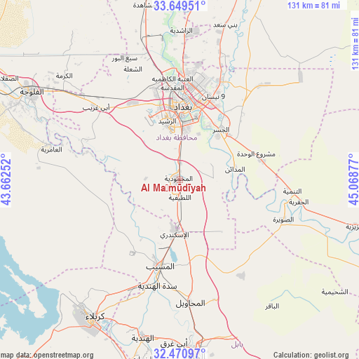
Al Maḩmūdīyah GPS coordinates[2]
33° 3' 43.956" North, 44° 21' 56.304" East
| Map corner | latitude | longitude |
|---|---|---|
| Upper-left | 33.64951°, | 43.66252° |
| Center: | 33.06221°, | 44.36564° |
| Lower-right: | 32.47097°, | 45.06877° |
| Map W x H: | 131×131 km | = 81.4×81.4mi |
| max Lat: | 37.22781° ⇑64.1% North |
| Al Maḩmūdīyah: | 33.06221° |
| min Lat: | ⇓35.9% South 29.97421° |
| min Long | Al Maḩmūdīy | max Long |
| 40.28586° | 44.36564° | 48.47309° |
| W 43.7%⇐ | ⇒56.3% E |
Elevation
Elevation of Al Maḩmūdīyah is 34 m = 112 ft, and this is 259 m = 850 ft below average elevation for this country.
| Max E: |
1316 m = 4318 ft | 69% |
| Avg. | 293 m = 961 ft | |
| Al Maḩmūdīyah | 34 m = 112 ft | |
Min E: |
1 m = 3 ft | 31% |
See also: Iraq elevation on elevation.city.
Geographical zone
Al Maḩmūdīyah is located in North temperate zone (between Tropic of Cancer and the Arctic Circle). Distance of this Northern Tropic circle is 1070.3 km =665.1 mi to South.| Distance of | km | miles | from Al Maḩmūdīyah |
|---|---|---|---|
| North Pole | 6330.9 | 3933.8 | to North |
| Arctic Circle | 3725 | 2314.6 | to North |
| Tropic Cancer | 1070.3 | 665.1 | to South |
| Equator | 3676.2 | 2284.3 | to South |


Nearby cities:
15 places around Al Maḩmūdīyah: (largest is in red/bold)
• Abū Ghurayb
31.9 km =19.8 mi,  328°
328°
• Al Fallūjah
62.7 km =39 mi,  300°
300°
• Al Hindīyah
58.8 km =36.5 mi,  192°
192°
• Al Hāshimīyah
82.4 km =51.2 mi,  160°
160°
• Al Maḩāwīl
44.7 km =27.8 mi,  174°
174°
• Al Musayyib
32.3 km =20.1 mi, 192°
• Al Ḩillah
66.7 km =41.4 mi,  175°
175°
• Al ‘Azīzīyah
67.3 km =41.8 mi,  104°
104°
• Aş Şuwayrah
41.2 km =25.6 mi,  111°
111°
• Aţ Ţārmīyah
68.1 km =42.3 mi,  2°
2°
• Baghdad
31.1 km =19.3 mi,  6°
6°
• Baqubah
80.1 km =49.8 mi,  16°
16°
• Karbala
58.9 km =36.6 mi,  212°
212°
• Khāliş
84.4 km =52.4 mi, 10°
• Nāḩīyat Saddat al Hindīyah
39.4 km =24.5 mi, 191°
Sources, notices
• [Note1] Compared only with cities in Iraq existing in our database
• [Src1] Map data: © OpenStreetMap contributors (CC-BY-SA)
• [Src2] Other city data from geonames.org with taken over terms of usage.
• [Src3] Geographical zone / Annual Mean Temperature by Robert A. Rohde @ Wikipedia
