Baghdad geodata
Baghdad is a capital of a political entity; located in Iraq in Asia/Baghdad (GMT+3) time zone. With population of 7,216,000 people, there are 0 cities with bigger population in this country. Compared to other cities in Iraq, 62% of cities are located further ↑North; 54.2% of cities are located further →East and 66.2% of cities have higher elevation than Baghdad. Note1


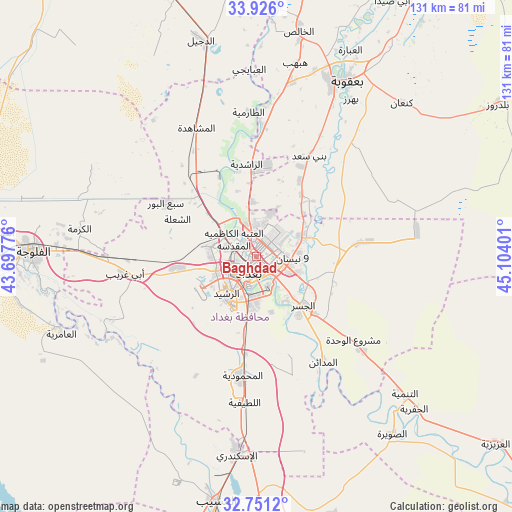
Baghdad GPS coordinates[2]
33° 20' 26.088" North, 44° 24' 3.168" East
| Map corner | latitude | longitude |
|---|---|---|
| Upper-left | 33.926°, | 43.69776° |
| Center: | 33.34058°, | 44.40088° |
| Lower-right: | 32.7512°, | 45.10401° |
| Map W x H: | 130.6×130.6 km | = 81.2×81.2mi |
| max Lat: | 37.22781° ⇑62% North |
| Baghdad: | 33.34058° |
| min Lat: | ⇓38% South 29.97421° |
| min Long | Baghdad | max Long |
| 40.28586° | 44.40088° | 48.47309° |
| W 45.8%⇐ | ⇒54.2% E |
Elevation
Elevation of Baghdad is 41 m = 135 ft, and this is 252 m = 827 ft below average elevation for this country.
| Max E: |
1316 m = 4318 ft | 66.2% |
| Avg. | 293 m = 961 ft | |
| Baghdad | 41 m = 135 ft | |
Min E: |
1 m = 3 ft | 33.8% |
See also: Baghdad elevation on elevation.city.
Geographical zone
Baghdad is located in North temperate zone (between Tropic of Cancer and the Arctic Circle). Distance of this Northern Tropic circle is 1101.2 km =684.3 mi to South.| Distance of | km | miles | from Baghdad |
|---|---|---|---|
| North Pole | 6299.9 | 3914.6 | to North |
| Arctic Circle | 3694 | 2295.3 | to North |
| Tropic Cancer | 1101.2 | 684.3 | to South |
| Equator | 3707.1 | 2303.5 | to South |


Nearby cities:
15 places around Baghdad: (largest is in red/bold)
• Abū Ghurayb
20.5 km =12.7 mi,  259°
259°
• Ad Dujayl
58.3 km =36.2 mi,  344°
344°
• Al Fallūjah
57.1 km =35.5 mi,  270°
270°
• Al Khāliş
57.8 km =35.9 mi,  11°
11°
• Al Maḩmūdīyah
31.1 km =19.3 mi,  186°
186°
• Al Maḩāwīl
75.5 km =46.9 mi,  179°
179°
• Al Musayyib
63.3 km =39.3 mi, 189°
• Al ‘Azīzīyah
78.1 km =48.5 mi,  127°
127°
• Aş Şuwayrah
57.9 km =36 mi,  142°
142°
• Aţ Ţārmīyah
37.1 km =23.1 mi,  359°
359°
• Balad
78.6 km =48.8 mi, 342°
• Baladrūz
74.2 km =46.1 mi,  57°
57°
• Baqubah
49.7 km =30.9 mi,  22°
22°
• Khāliş
53.4 km =33.2 mi, 13°
• Nāḩīyat Saddat al Hindīyah
70.4 km =43.7 mi, 189°
Sources, notices
• [Note1] Compared only with cities in Iraq existing in our database
• [Src1] Map data: © OpenStreetMap contributors (CC-BY-SA)
• [Src2] Other city data from geonames.org with taken over terms of usage.
• [Src3] Geographical zone / Annual Mean Temperature by Robert A. Rohde @ Wikipedia
