Najaf geodata
Najaf (An Najaf) is a seat of a first-order administrative division; located in Iraq in Asia/Baghdad (GMT+3) time zone. With population of 482,576 people, there are 9 cities with bigger population in this country. Compared to other cities in Iraq, 78.2% of cities are located further ↑North; 57% of cities are located further →East and 66.2% of cities have higher elevation than Najaf. Note1


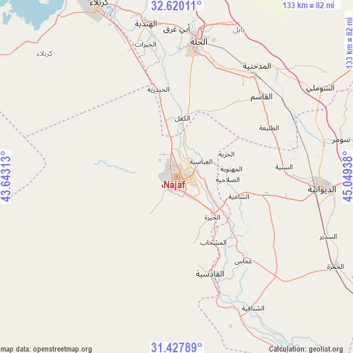
Najaf GPS coordinates[2]
32° 1' 33.384" North, 44° 20' 46.5" East
| Map corner | latitude | longitude |
|---|---|---|
| Upper-left | 32.62011°, | 43.64313° |
| Center: | 32.02594°, | 44.34625° |
| Lower-right: | 31.42789°, | 45.04938° |
| Map W x H: | 132.6×132.6 km | = 82.4×82.4mi |
| max Lat: | 37.22781° ⇑78.2% North |
| Najaf: | 32.02594° |
| min Lat: | ⇓21.8% South 29.97421° |
| min Long | Najaf | max Long |
| 40.28586° | 44.34625° | 48.47309° |
| W 43%⇐ | ⇒57% E |
Elevation
Elevation of Najaf is 41 m = 135 ft, and this is 252 m = 827 ft below average elevation for this country.
| Max E: |
1316 m = 4318 ft | 66.2% |
| Avg. | 293 m = 961 ft | |
| Najaf | 41 m = 135 ft | |
Min E: |
1 m = 3 ft | 33.8% |
See also: Najaf elevation on elevation.city.
Geographical zone
Najaf is located in North temperate zone (between Tropic of Cancer and the Arctic Circle). Distance of this Northern Tropic circle is 955 km =593.4 mi to South.| Distance of | km | miles | from Najaf |
|---|---|---|---|
| North Pole | 6446.1 | 4005.4 | to North |
| Arctic Circle | 3840.2 | 2386.2 | to North |
| Tropic Cancer | 955 | 593.4 | to South |
| Equator | 3561 | 2212.7 | to South |


Nearby cities:
15 places around Najaf: (largest is in red/bold)
• Ad Dīwānīyah
54.7 km =34 mi,  93°
93°
• Al Hindīyah
59 km =36.7 mi,  349°
349°
• Al Hāshimīyah
47.8 km =29.7 mi,  38°
38°
• Al Manādhirah
18.7 km =11.6 mi,  135°
135°
• Al Maḩāwīl
70.9 km =44.1 mi,  4°
4°
• Al Mishkhāb
28.1 km =17.5 mi,  151°
151°
• Al Ḩamzah
68.3 km =42.4 mi,  119°
119°
• Al Ḩillah
49.2 km =30.6 mi,  8°
8°
• Ash Shāmīyah
25 km =15.5 mi,  106°
106°
• Imam Qasim
43.8 km =27.2 mi,  46°
46°
• Karbala
72.2 km =44.9 mi,  335°
335°
• Kufa
9.3 km =5.8 mi,  72°
72°
• Nahiyat Ghammas
40.7 km =25.3 mi, 140°
• Nāḩiyat ash Shināfīyah
56.8 km =35.3 mi, 149°
• Nāḩīyat Saddat al Hindīyah
76.9 km =47.8 mi,  355°
355°
In other languages:
- In Spanish: Nayaf
- In France: Nadjaf
- In German: Nadschaf
- In Russian: Эн-Наджаф
- In Chinese: 納杰夫
Sources, notices
• [Note1] Compared only with cities in Iraq existing in our database
• [Src1] Map data: © OpenStreetMap contributors (CC-BY-SA)
• [Src2] Other city data from geonames.org with taken over terms of usage.
• [Src3] Geographical zone / Annual Mean Temperature by Robert A. Rohde @ Wikipedia
