Dehāqān geodata
Dehāqān (Isfahan) is a seat of a second-order administrative division; located in Iran in Asia/Tehran (GMT+3.5) time zone. In our database, there are 232 cities with bigger population. Compared to other cities in Iran, 70.1% of cities are located further ↑North; 56.5% of cities are located further ←West and 94.8% of cities have lower elevation than Dehāqān. Note1


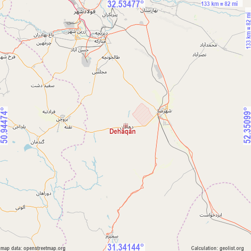
Dehāqān GPS coordinates[2]
31° 56' 24.144" North, 51° 38' 52.296" East
| Map corner | latitude | longitude |
|---|---|---|
| Upper-left | 32.53477°, | 50.94474° |
| Center: | 31.94004°, | 51.64786° |
| Lower-right: | 31.34144°, | 52.35099° |
| Map W x H: | 132.7×132.7 km | = 82.5×82.5mi |
| max Lat: | 39.6482° ⇑70.1% North |
| Dehāqān: | 31.94004° |
| min Lat: | ⇓29.9% South 25.2919° |
| min Long | Dehāqān | max Long |
| 44.38416° | 51.64786° | 61.9965° |
| W 56.5%⇐ | ⇒43.5% E |
Elevation
Elevation of Dehāqān is 2045 m = 6709 ft, and this is 996 m = 3268 ft above average elevation for this country.
| Max E: |
2564 m = 8412 ft | 5.2% |
| Dehāqān | 2045 m 6709 ft | |
| Avg. | 1049 m = 3442 ft | |
Min E: |
-24 m = -79 ft | 94.8% |
See also: Iran elevation on elevation.city.
Geographical zone
Dehāqān is located in North temperate zone (between Tropic of Cancer and the Arctic Circle). Distance of this Northern Tropic circle is 945.5 km =587.5 mi to South.| Distance of | km | miles | from Dehāqān |
|---|---|---|---|
| North Pole | 6455.7 | 4011.4 | to North |
| Arctic Circle | 3849.8 | 2392.2 | to North |
| Tropic Cancer | 945.5 | 587.5 | to South |
| Equator | 3551.4 | 2206.7 | to South |


Nearby cities:
15 places around Dehāqān: (largest is in red/bold)
• Abrīsham
68.9 km =42.8 mi,  354°
354°
• Borūjen
34.1 km =21.2 mi,  274°
274°
• Dorcheh Pīāz
75.6 km =47 mi, 353°
• Falāvarjān
69.6 km =43.2 mi, 349°
• Farrokh Shahr
72.9 km =45.3 mi,  300°
300°
• Isfahan
79.3 km =49.3 mi,  1°
1°
• Kelīshād va Sūdarjān
68.9 km =42.8 mi, 350°
• Mobārakeh
47.2 km =29.3 mi,  343°
343°
• Najafābād
81.6 km =50.7 mi, 341°
• Qahderījān
73.1 km =45.4 mi, 345°
• Rehnān
82.8 km =51.4 mi,  356°
356°
• Semīrom
58.7 km =36.5 mi,  187°
187°
• Shahreẕā
22 km =13.7 mi,  69°
69°
• Shalamzār
79.3 km =49.3 mi,  278°
278°
• Zarrīn Shahr
56.1 km =34.9 mi,  332°
332°
Sources, notices
• [Note1] Compared only with cities in Iran existing in our database
• [Src1] Map data: © OpenStreetMap contributors (CC-BY-SA)
• [Src2] Other city data from geonames.org with taken over terms of usage.
• [Src3] Geographical zone / Annual Mean Temperature by Robert A. Rohde @ Wikipedia
