Shahreẕā geodata
Shahreẕā (Isfahan) is a seat of a second-order administrative division; located in Iran in Asia/Tehran (GMT+3.5) time zone. In our database, there are 232 cities with bigger population. Compared to other cities in Iran, 69.4% of cities are located further ↑North; 58% of cities are located further ←West and 86.8% of cities have lower elevation than Shahreẕā. Note1


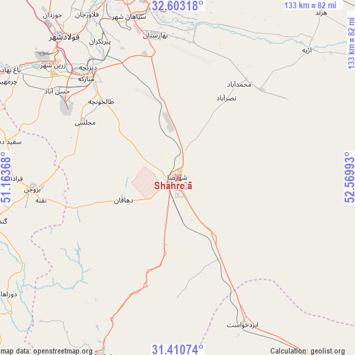
Shahreẕā GPS coordinates[2]
32° 0' 32.04" North, 51° 52' 0.48" East
| Map corner | latitude | longitude |
|---|---|---|
| Upper-left | 32.60318°, | 51.16368° |
| Center: | 32.0089°, | 51.8668° |
| Lower-right: | 31.41074°, | 52.56993° |
| Map W x H: | 132.6×132.6 km | = 82.4×82.4mi |
| max Lat: | 39.6482° ⇑69.4% North |
| Shahreẕā: | 32.0089° |
| min Lat: | ⇓30.6% South 25.2919° |
| min Long | Shahreẕā | max Long |
| 44.38416° | 51.8668° | 61.9965° |
| W 58%⇐ | ⇒42% E |
Elevation
Elevation of Shahreẕā is 1823 m = 5981 ft, and this is 774 m = 2539 ft above average elevation for this country.
| Max E: |
2564 m = 8412 ft | 13.2% |
| Shahreẕā | 1823 m 5981 ft | |
| Avg. | 1049 m = 3442 ft | |
Min E: |
-24 m = -79 ft | 86.8% |
See also: Iran elevation on elevation.city.
Geographical zone
Shahreẕā is located in North temperate zone (between Tropic of Cancer and the Arctic Circle). Distance of this Northern Tropic circle is 953.1 km =592.2 mi to South.| Distance of | km | miles | from Shahreẕā |
|---|---|---|---|
| North Pole | 6448 | 4006.6 | to North |
| Arctic Circle | 3842.1 | 2387.4 | to North |
| Tropic Cancer | 953.1 | 592.2 | to South |
| Equator | 3559.1 | 2211.5 | to South |


Nearby cities:
15 places around Shahreẕā: (largest is in red/bold)
• Abrīsham
66.8 km =41.5 mi,  335°
335°
• Borūjen
54.9 km =34.1 mi,  264°
264°
• Dehāqān
22 km =13.7 mi,  249°
249°
• Dorcheh Pīāz
73.5 km =45.7 mi, 336°
• Falāvarjān
69.4 km =43.1 mi,  331°
331°
• Farrokh Shahr
88.5 km =55 mi,  289°
289°
• Isfahan
73.8 km =45.9 mi,  345°
345°
• Kelīshād va Sūdarjān
68.2 km =42.4 mi, 332°
• Khomeynī Shahr
81.4 km =50.6 mi, 337°
• Mobārakeh
50.7 km =31.5 mi,  317°
317°
• Najafābād
83.9 km =52.1 mi, 325°
• Qahderījān
74.1 km =46 mi, 328°
• Rehnān
79 km =49.1 mi, 341°
• Semīrom
71.7 km =44.6 mi,  203°
203°
• Zarrīn Shahr
62.6 km =38.9 mi,  312°
312°
Sources, notices
• [Note1] Compared only with cities in Iran existing in our database
• [Src1] Map data: © OpenStreetMap contributors (CC-BY-SA)
• [Src2] Other city data from geonames.org with taken over terms of usage.
• [Src3] Geographical zone / Annual Mean Temperature by Robert A. Rohde @ Wikipedia
