Semīrom geodata
Semīrom (Isfahan) is a populated place; located in Iran in Asia/Tehran (GMT+3.5) time zone. With population of 27,220 people, there are 183 cities with bigger population in this country. Compared to other cities in Iran, 73.5% of cities are located further ↑North; 55.1% of cities are located further ←West and 99.5% of cities have lower elevation than Semīrom. Note1


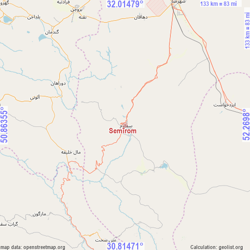
Semīrom GPS coordinates[2]
31° 25' 0.012" North, 51° 34' 0.012" East
| Map corner | latitude | longitude |
|---|---|---|
| Upper-left | 32.01479°, | 50.86355° |
| Center: | 31.41667°, | 51.56667° |
| Lower-right: | 30.81471°, | 52.2698° |
| Map W x H: | 133.4×133.4 km | = 82.9×82.9mi |
| max Lat: | 39.6482° ⇑73.5% North |
| Semīrom: | 31.41667° |
| min Lat: | ⇓26.5% South 25.2919° |
| min Long | Semīrom | max Long |
| 44.38416° | 51.56667° | 61.9965° |
| W 55.1%⇐ | ⇒44.9% E |
Elevation
Elevation of Semīrom is 2425 m = 7956 ft, and this is 1376 m = 4514 ft above average elevation for this country.
| Max E: |
2564 m = 8412 ft | 0.5% |
| Semīrom | 2425 m 7956 ft | |
| Avg. | 1049 m = 3442 ft | |
Min E: |
-24 m = -79 ft | 99.5% |
See also: Iran elevation on elevation.city.
Geographical zone
Semīrom is located in North temperate zone (between Tropic of Cancer and the Arctic Circle). Distance of this Northern Tropic circle is 887.3 km =551.3 mi to South.| Distance of | km | miles | from Semīrom |
|---|---|---|---|
| North Pole | 6513.9 | 4047.5 | to North |
| Arctic Circle | 3908 | 2428.3 | to North |
| Tropic Cancer | 887.3 | 551.3 | to South |
| Equator | 3493.2 | 2170.6 | to South |


Nearby cities:
15 places around Semīrom: (largest is in red/bold)
• Ardal
107.3 km =66.7 mi,  307°
307°
• Borūjen
66.5 km =41.3 mi,  336°
336°
• Dehdasht
117.8 km =73.2 mi,  234°
234°
• Dehāqān
58.7 km =36.5 mi,  7°
7°
• Eqlīd
122 km =75.8 mi,  118°
118°
• Farrokh Shahr
110 km =68.4 mi,  329°
329°
• Lordegān
71 km =44.1 mi,  278°
278°
• Mobārakeh
103.6 km =64.4 mi,  356°
356°
• Shahr-e Kord
121.3 km =75.4 mi, 326°
• Shahreẕā
71.7 km =44.6 mi,  23°
23°
• Shalamzār
99.7 km =62 mi, 314°
• Sīsakht
62.4 km =38.8 mi,  189°
189°
• Yasuj
83.2 km =51.7 mi,  178°
178°
• Zarrīn Shahr
109.7 km =68.2 mi,  350°
350°
• Ābādeh
106.8 km =66.4 mi,  105°
105°
Sources, notices
• [Note1] Compared only with cities in Iran existing in our database
• [Src1] Map data: © OpenStreetMap contributors (CC-BY-SA)
• [Src2] Other city data from geonames.org with taken over terms of usage.
• [Src3] Geographical zone / Annual Mean Temperature by Robert A. Rohde @ Wikipedia
