Lordegān geodata
Lordegān (Chaharmahal and Bakhtiari) is a seat of a second-order administrative division; located in Iran in Asia/Tehran (GMT+3.5) time zone. In our database, there are 232 cities with bigger population. Compared to other cities in Iran, 72.8% of cities are located further ↑North; 54.6% of cities are located further →East and 75.3% of cities have lower elevation than Lordegān. Note1


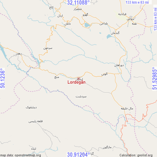
Lordegān GPS coordinates[2]
31° 30' 48.168" North, 50° 49' 36.192" East
| Map corner | latitude | longitude |
|---|---|---|
| Upper-left | 32.11088°, | 50.1236° |
| Center: | 31.51338°, | 50.82672° |
| Lower-right: | 30.91204°, | 51.52985° |
| Map W x H: | 133.3×133.3 km | = 82.8×82.8mi |
| max Lat: | 39.6482° ⇑72.8% North |
| Lordegān: | 31.51338° |
| min Lat: | ⇓27.2% South 25.2919° |
| min Long | Lordegān | max Long |
| 44.38416° | 50.82672° | 61.9965° |
| W 45.4%⇐ | ⇒54.6% E |
Elevation
Elevation of Lordegān is 1588 m = 5210 ft, and this is 539 m = 1768 ft above average elevation for this country.
| Max E: |
2564 m = 8412 ft | 24.7% |
| Lordegān | 1588 m 5210 ft | |
| Avg. | 1049 m = 3442 ft | |
Min E: |
-24 m = -79 ft | 75.3% |
See also: Iran elevation on elevation.city.
Geographical zone
Lordegān is located in North temperate zone (between Tropic of Cancer and the Arctic Circle). Distance of this Northern Tropic circle is 898 km =558 mi to South.| Distance of | km | miles | from Lordegān |
|---|---|---|---|
| North Pole | 6503.1 | 4040.8 | to North |
| Arctic Circle | 3897.2 | 2421.6 | to North |
| Tropic Cancer | 898 | 558 | to South |
| Equator | 3504 | 2177.3 | to South |


Nearby cities:
15 places around Lordegān: (largest is in red/bold)
• Ardal
56.3 km =35 mi,  343°
343°
• Borūjen
66.5 km =41.3 mi,  40°
40°
• Bāgh-e Malek
89.2 km =55.4 mi,  270°
270°
• Dehdasht
83.7 km =52 mi,  197°
197°
• Dehāqān
91 km =56.5 mi,  58°
58°
• Farrokh Shahr
85.6 km =53.2 mi,  9°
9°
• Fārsān
86.4 km =53.7 mi, 343°
• Līkak
98 km =60.9 mi,  225°
225°
• Mobārakeh
112.6 km =70 mi,  34°
34°
• Semīrom
71 km =44.1 mi,  98°
98°
• Shahr-e Kord
90.4 km =56.2 mi,  1°
1°
• Shahreẕā
112.7 km =70 mi, 60°
• Shalamzār
59.3 km =36.8 mi,  359°
359°
• Sīsakht
93.8 km =58.3 mi,  140°
140°
• Zarrīn Shahr
110.4 km =68.6 mi, 28°
Sources, notices
• [Note1] Compared only with cities in Iran existing in our database
• [Src1] Map data: © OpenStreetMap contributors (CC-BY-SA)
• [Src2] Other city data from geonames.org with taken over terms of usage.
• [Src3] Geographical zone / Annual Mean Temperature by Robert A. Rohde @ Wikipedia
