Qā’em Shahr geodata
Qā’em Shahr (Māzandarān) is a seat of a second-order administrative division; located in Iran in Asia/Tehran (GMT+3.5) time zone. In our database, there are 232 cities with bigger population. Compared to other cities in Iran, 73.9% of cities are located further ↓South; 64.6% of cities are located further ←West and 86.2% of cities have higher elevation than Qā’em Shahr. Note1


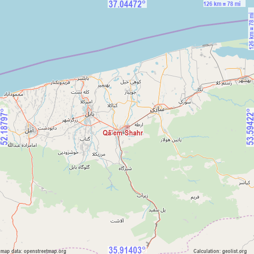
Qā’em Shahr GPS coordinates[2]
36° 28' 53.184" North, 52° 53' 27.924" East
| Map corner | latitude | longitude |
|---|---|---|
| Upper-left | 37.04472°, | 52.18797° |
| Center: | 36.48144°, | 52.89109° |
| Lower-right: | 35.91403°, | 53.59422° |
| Map W x H: | 125.7×125.7 km | = 78.1×78.1mi |
| max Lat: | 39.6482° ⇑26.1% North |
| Qā’em Shahr: | 36.48144° |
| min Lat: | ⇓73.9% South 25.2919° |
| min Long | Qā’em Shahr | max Long |
| 44.38416° | 52.89109° | 61.9965° |
| W 64.6%⇐ | ⇒35.4% E |
Elevation
Elevation of Qā’em Shahr is 38 m = 125 ft, and this is 1011 m = 3317 ft below average elevation for this country.
| Max E: |
2564 m = 8412 ft | 86.2% |
| Avg. | 1049 m = 3442 ft | |
| Qā’em Shahr | 38 m = 125 ft | |
Min E: |
-24 m = -79 ft | 13.8% |
See also: Iran elevation on elevation.city.
Geographical zone
Qā’em Shahr is located in North temperate zone (between Tropic of Cancer and the Arctic Circle). Distance of this Northern Tropic circle is 1450.4 km =901.2 mi to South.| Distance of | km | miles | from Qā’em Shahr |
|---|---|---|---|
| North Pole | 5950.7 | 3697.6 | to North |
| Arctic Circle | 3344.8 | 2078.4 | to North |
| Tropic Cancer | 1450.4 | 901.2 | to South |
| Equator | 4056.4 | 2520.5 | to South |


Nearby cities:
15 places around Qā’em Shahr: (largest is in red/bold)
• Behshahr
63.5 km =39.5 mi,  68°
68°
• Bābol
20.5 km =12.7 mi,  292°
292°
• Bābolsar
32.2 km =20 mi,  319°
319°
• Fereydūnkenār
40 km =24.9 mi,  304°
304°
• Fīrūzkūh
81.3 km =50.5 mi,  187°
187°
• Galūgāh
86.4 km =53.7 mi, 71°
• Jūybār
17.9 km =11.1 mi,  6°
6°
• Maḩmūdābād
58.6 km =36.4 mi, 286°
• Nekā
41 km =25.5 mi,  62°
62°
• Nūr
78.9 km =49 mi,  277°
277°
• Pol-e Sefīd
43 km =26.7 mi,  159°
159°
• Sari
17.6 km =10.9 mi, 58°
• Soleh Bon
84.6 km =52.6 mi,  200°
200°
• Sūrak
31 km =19.3 mi, 65°
• Āmol
48.3 km =30 mi,  268°
268°
Sources, notices
• [Note1] Compared only with cities in Iran existing in our database
• [Src1] Map data: © OpenStreetMap contributors (CC-BY-SA)
• [Src2] Other city data from geonames.org with taken over terms of usage.
• [Src3] Geographical zone / Annual Mean Temperature by Robert A. Rohde @ Wikipedia
