Fīrūzkūh geodata
Fīrūzkūh (Tehrān) is a seat of a second-order administrative division; located in Iran in Asia/Tehran (GMT+3.5) time zone. In our database, there are 232 cities with bigger population. Compared to other cities in Iran, 66.4% of cities are located further ↓South; 63.7% of cities are located further ←West and 92.7% of cities have lower elevation than Fīrūzkūh. Note1


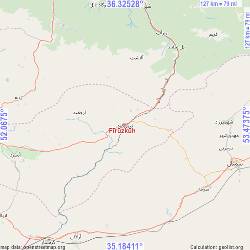
Fīrūzkūh GPS coordinates[2]
35° 45' 24.264" North, 52° 46' 14.232" East
| Map corner | latitude | longitude |
|---|---|---|
| Upper-left | 36.32528°, | 52.0675° |
| Center: | 35.75674°, | 52.77062° |
| Lower-right: | 35.18411°, | 53.47375° |
| Map W x H: | 126.9×126.9 km | = 78.9×78.9mi |
| max Lat: | 39.6482° ⇑33.6% North |
| Fīrūzkūh: | 35.75674° |
| min Lat: | ⇓66.4% South 25.2919° |
| min Long | Fīrūzkūh | max Long |
| 44.38416° | 52.77062° | 61.9965° |
| W 63.7%⇐ | ⇒36.3% E |
Elevation
Elevation of Fīrūzkūh is 1943 m = 6375 ft, and this is 894 m = 2933 ft above average elevation for this country.
| Max E: |
2564 m = 8412 ft | 7.3% |
| Fīrūzkūh | 1943 m 6375 ft | |
| Avg. | 1049 m = 3442 ft | |
Min E: |
-24 m = -79 ft | 92.7% |
See also: Iran elevation on elevation.city.
Geographical zone
Fīrūzkūh is located in North temperate zone (between Tropic of Cancer and the Arctic Circle). Distance of this Northern Tropic circle is 1369.9 km =851.2 mi to South.| Distance of | km | miles | from Fīrūzkūh |
|---|---|---|---|
| North Pole | 6031.3 | 3747.7 | to North |
| Arctic Circle | 3425.4 | 2128.4 | to North |
| Tropic Cancer | 1369.9 | 851.2 | to South |
| Equator | 3975.8 | 2470.4 | to South |


Nearby cities:
15 places around Fīrūzkūh: (largest is in red/bold)
• Bābol
88.7 km =55.1 mi,  354°
354°
• Damāvand
63.4 km =39.4 mi,  266°
266°
• Garmsār
71.4 km =44.4 mi,  213°
213°
• Jūybār
99.2 km =61.6 mi,  7°
7°
• Mahdishahr
52.9 km =32.9 mi,  95°
95°
• Pol-e Sefīd
47.6 km =29.6 mi,  32°
32°
• Qā’em Shahr
81.3 km =50.5 mi, 7°
• Sari
93.4 km =58 mi,  16°
16°
• Semnan
59.6 km =37 mi,  109°
109°
• Sharīfābād
96.3 km =59.8 mi,  247°
247°
• Soleh Bon
19 km =11.8 mi, 273°
• Sorkheh
51.7 km =32.1 mi,  129°
129°
• Āmol
87.8 km =54.6 mi,  334°
334°
• Ārādān
61.7 km =38.3 mi,  203°
203°
• Īstgāh-e Rāh Āhan-e Garmsār
71.5 km =44.4 mi,  215°
215°
Sources, notices
• [Note1] Compared only with cities in Iran existing in our database
• [Src1] Map data: © OpenStreetMap contributors (CC-BY-SA)
• [Src2] Other city data from geonames.org with taken over terms of usage.
• [Src3] Geographical zone / Annual Mean Temperature by Robert A. Rohde @ Wikipedia
