Soleh Bon geodata
Soleh Bon (Tehrān) is a populated place; located in Iran in Asia/Tehran (GMT+3.5) time zone. With population of 1,500 people, there are 225 cities with bigger population in this country. Compared to other cities in Iran, 66.9% of cities are located further ↓South; 61.9% of cities are located further ←West and 94.1% of cities have lower elevation than Soleh Bon. Note1


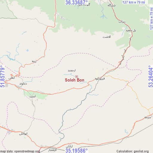
Soleh Bon GPS coordinates[2]
35° 46' 6.276" North, 52° 33' 39.276" East
| Map corner | latitude | longitude |
|---|---|---|
| Upper-left | 36.33687°, | 51.85779° |
| Center: | 35.76841°, | 52.56091° |
| Lower-right: | 35.19586°, | 53.26404° |
| Map W x H: | 126.9×126.9 km | = 78.9×78.9mi |
| max Lat: | 39.6482° ⇑33.1% North |
| Soleh Bon: | 35.76841° |
| min Lat: | ⇓66.9% South 25.2919° |
| min Long | Soleh Bon | max Long |
| 44.38416° | 52.56091° | 61.9965° |
| W 61.9%⇐ | ⇒38.1% E |
Elevation
Elevation of Soleh Bon is 2011 m = 6598 ft, and this is 962 m = 3156 ft above average elevation for this country.
| Max E: |
2564 m = 8412 ft | 5.9% |
| Soleh Bon | 2011 m 6598 ft | |
| Avg. | 1049 m = 3442 ft | |
Min E: |
-24 m = -79 ft | 94.1% |
See also: Iran elevation on elevation.city.
Geographical zone
Soleh Bon is located in North temperate zone (between Tropic of Cancer and the Arctic Circle). Distance of this Northern Tropic circle is 1371.2 km =852 mi to South.| Distance of | km | miles | from Soleh Bon |
|---|---|---|---|
| North Pole | 6030 | 3746.9 | to North |
| Arctic Circle | 3424.1 | 2127.6 | to North |
| Tropic Cancer | 1371.2 | 852 | to South |
| Equator | 3977.1 | 2471.3 | to South |


Nearby cities:
15 places around Soleh Bon: (largest is in red/bold)
• Bābol
87.7 km =54.5 mi,  6°
6°
• Damāvand
44.7 km =27.8 mi,  262°
262°
• Fīrūzkūh
19 km =11.8 mi,  93°
93°
• Garmsār
64.3 km =40 mi,  198°
198°
• Mahdishahr
71.9 km =44.7 mi,  95°
95°
• Pol-e Sefīd
59.1 km =36.7 mi,  48°
48°
• Pākdasht
85.6 km =53.2 mi,  247°
247°
• Pīshvā
91.2 km =56.7 mi,  235°
235°
• Qā’em Shahr
84.6 km =52.6 mi,  20°
20°
• Semnan
78 km =48.5 mi,  105°
105°
• Sharīfābād
79.7 km =49.5 mi, 241°
• Sorkheh
68.1 km =42.3 mi,  119°
119°
• Āmol
80.2 km =49.8 mi,  346°
346°
• Ārādān
58 km =36 mi,  185°
185°
• Īstgāh-e Rāh Āhan-e Garmsār
63.6 km =39.5 mi, 200°
Sources, notices
• [Note1] Compared only with cities in Iran existing in our database
• [Src1] Map data: © OpenStreetMap contributors (CC-BY-SA)
• [Src2] Other city data from geonames.org with taken over terms of usage.
• [Src3] Geographical zone / Annual Mean Temperature by Robert A. Rohde @ Wikipedia
