Seyðisfjörður geodata
Seyðisfjörður (East) is a populated place; located in Iceland in Atlantic/Reykjavik (GMT+0) time zone. With population of 658 people, there are 38 cities with bigger population in this country. Compared to other cities in Iceland, 67.4% of cities are located further ↓South; 97.8% of cities are located further ←West and 69.6% of cities have lower elevation than Seyðisfjörður. Note1


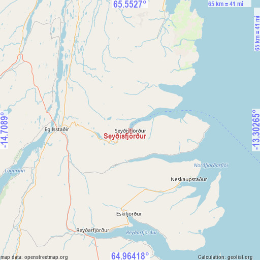
Seyðisfjörður GPS coordinates[2]
65° 15' 36.288" North, 14° 0' 20.772" West
| Map corner | latitude | longitude |
|---|---|---|
| Upper-left | 65.5527°, | -14.7089° |
| Center: | 65.26008°, | -14.00577° |
| Lower-right: | 64.96418°, | -13.30265° |
| Map W x H: | 65.4×65.4 km | = 40.6×40.6mi |
| max Lat: | 66.15917° ⇑32.6% North |
| Seyðisfjörður: | 65.26008° |
| min Lat: | ⇓67.4% South 63.44273° |
| min Long | Seyðisfjörðu | max Long |
| -23.99596° | -14.00577° | -13.68368° |
| W 97.8%⇐ | ⇒2.2% E |
Elevation
Elevation of Seyðisfjörður is 29 m = 95 ft, and this is 7.7 m = 25 ft above average elevation for this country.
| Max E: |
105 m = 344 ft | 30.4% |
| Seyðisfjörður | 29 m 95 ft | |
| Avg. | 21.3 m = 70 ft | |
Min E: |
1 m = 3 ft | 69.6% |
See also: Iceland elevation on elevation.city.
Geographical zone
Seyðisfjörður is located in North temperate zone (between Tropic of Cancer and the Arctic Circle). Distance of this North polar circle is 144.9 km =90 mi to North.| Distance of | km | miles | from Seyðisfjörður |
|---|---|---|---|
| North Pole | 2750.8 | 1709.3 | to North |
| Arctic Circle | 144.9 | 90 | to North |
| Tropic Cancer | 4650.3 | 2889.6 | to South |
| Equator | 7256.2 | 4508.8 | to South |


Nearby cities:
9 places around Seyðisfjörður: (largest is in red/bold)
• Egilsstaðir
18.1 km =11.2 mi,  272°
272°
• Eskifjörður
20.8 km =12.9 mi,  181°
181°
• Fáskrúðsfjörður
36.6 km =22.7 mi, 180°
• Höfn
125.6 km =78 mi,  207°
207°
• Húsavík
175.7 km =109.2 mi,  299°
299°
• Laugar
163.6 km =101.7 mi,  288°
288°
• Neskaupstaður
19.5 km =12.1 mi,  129°
129°
• Reyðarfjörður
27.3 km =17 mi,  201°
201°
• Vopnafjörður
67 km =41.6 mi,  325°
325°
Sources, notices
• [Note1] Compared only with cities in Iceland existing in our database
• [Src1] Map data: © OpenStreetMap contributors (CC-BY-SA)
• [Src2] Other city data from geonames.org with taken over terms of usage.
• [Src3] Geographical zone / Annual Mean Temperature by Robert A. Rohde @ Wikipedia
